Carson Mounds
The Carson site, also known as the Carson Mounds and/or Carson-Montgomery-Stovall [1][2][3] was once a large Mississippian culture site along the Mississippi River in the Yazoo Basin of Mississippi.[4] The site was first occupied in the middle of the first millennium A.D. and the large earthen monuments and villages were constructed at the site after A.D. 1200.[5] Only a few large earthen mounds are still present at Carson to this day. Some archaeologists have suggested that Carson was one of the more important archaeological sites in the state of Mississippi.[6][7]
Archaeologists have also suggested that Carson is important because it was either near or part of one of the provinces visited by some of the earliest conquistadors in the southeastern United States.[8][9] There is no physical evidence that Carson was visited by Hernando de Soto and his men during the westward trek across the southeastern United States. However, they did pass at the very least within 50 – 75 km of Carson and the social disruptions caused by Soto and his men did cause native polities and provinces like Carson to defragment and fall apart .
Carson was first visited by early European explorers in the late nineteenth century, including surveyors for Smithsonian's Bureau of American Ethnology, Col. Philetus W. Norris and William Henry Holmes.[10] The site was located on the Oasis Plantation owned by the Stovall and Carson families and a map of the landscape and mounds was published in 1894 in the 12th Annual Report to the Bureau of American Ethnology by Cyrus Thomas. Subsequent researchers to visit the site include the Harvard LMS survey, Ian Brown, Jay K. Johnson, John Connaway, and Jayur Madhusudan Mehta.[11][12][13]
This map, in addition to research by archaeologists, established the significant scale of settlement at the site. The mounds stretch across an expanse of land over 1.6 km in length. In the greater pantheon of Mississippian culture sites, Carson is quite large, and it was incredibly important in local and regional political dynamics.[14]
Site Characteristics
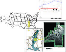
Carson is located in the northern Yazoo Basin, approximately 500 km north from the Gulf of Mexico and 120 km south from Memphis, Tennessee. The Yazoo Basin is a floodplain of the Mississippi River and features a variety of geomorphic features created by meandering channels of the Mississippi River.[15] Carson and the mounds were constructed over a crevasse splay which was deposited by the Mississippi River around 2800 years ago.[16] The modern city of Clarksdale, Mississippi is nearby.[17]
Built environment
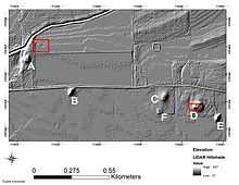
The Mississippian culture component of Carson is presently dominated by five large flat-topped earthen mounds; in 1894 and well before extensive European settlement in the region, there were over eighty small mounds scattered around the landscape as well.[18] Most of these small mounds are no longer present on the landscape. The remaining mounds, named Mounds A-F, are anywhere between 3 to 12 meters in height. Some of the earthen mounds were formed in arrangements around plazas. Adjacent to Mound A, there was a large enclosed village where archaeologists have currently recovered well over 30 residential buildings.[19]
Some of these buildings have produced evidence of flint-knapping, the production of stone tools, some of which are consistent with blades and drills found at other major Mississippian mound centers including Cahokia and Bottle Creek.[20] Other evidence of interaction with Cahokia comes in the form of Ramey Incised vessels, which are characteristic Cahokia vessels, and which have been found at Carson. Examples of these vessels can be found at the Carnegie Public Library in Clarksdale, Mississippi.[21]
References
- ↑ Phillips et al 2003
- ↑ Brown 1978
- ↑ Brown 1926
- ↑ Johnson 1987
- ↑ Mehta et al 2012
- ↑ Brown 1978
- ↑ Mehta et al 2012
- ↑ Brain et al 1974
- ↑ Hudson 1997
- ↑ Thomas 1891, 1894
- ↑ Johnson 1987
- ↑ Brown 1978
- ↑ Phillips et al 1951
- ↑ Dye and Cox 1990
- ↑ Saucier 1994
- ↑ Mehta et al 2012
- ↑ Mississippi Blues Trail
- ↑ Thomas 1894
- ↑ Mehta et al 2012
- ↑ Johnson 1987
- ↑ Carnegie Public Library
Brain, Jeffrey P, Alan Toth, and A. Rodriguez-Buckingham 1974 Ethnohistoric Archaeology and the De Soto Entrada into the Lower Mississippi Valley. In The Conference on Historic Site Papers 1772, 7:223-298.
Brown, Calvin 1992 Archaeology of Mississippi. University Press of Mississippi, Jackson. Originally published [1926] by the Mississippi Geological Survey, Mississippi.
Brown, Ian W. 1978 An Archaeological Survey of Mississippi Period Sites in Coahoma County, Mississippi: Final Report. Unpublished ms., Cottonlandia Museum, Greenwood, Mississippi, and Lower Mississippi Survey, Peabody Museum, Harvard University, Cambridge.
Dye, David H., and Cheryl A. Cox (editors) 1990 Towns and Temples Along the Mississippi. University of Alabama, Tuscaloosa.
Ethridge, Robbie 2010 From Chicaza to Chickasaw: The European Invasion and the Transformation of the Mississippian World, 1540 – 1715. The University of North Carolina Press, Chapel Hill.
Johnson, Jay K. 1987 Cahokia Core Technology in Mississipp: The View from the South. In The Organization of Core Technology, edited by Jay K. Johnson and Carol A. Morrow, pp. 187–206. Westview Press, Boulder and London.
Knight, Vernon J. 1986 The Institutional Organization of Mississippian Religion. American Antiquity 51(4):675-687.
Mehta, Jayur Madhusudan, Kelsey M. Lowe, Rachel Stout-Evans, and John Connaway 2012 Moving Earth and Building Monuments at the Carson Mounds Site, Coahoma County, Mississippi. Journal of Anthropology 2012:1-21.
Phillips, Philip, James A. Ford, and James B. Griffin 2003 Archaeological Survey in the Lower Mississippi Alluvial Valley, 1940-1947. Reprinted [1951] with and introduction and edited by Stephen Williams, University of Alabama Press, Tuscaloosa. Originally printed as Papers of the Peabody Museum of Archaeology and Ethnology, Harvard University, Vol. 25, Cambridge.
Saucier, Roger T. 1994 Geomorphology and Quaternary Geology of the Lower Mississippi Valley, 2 vols. Army Engineer Waterways Experiment Station, Vicksburg, MS.
Thomas, Cyrus 1891 Catalog of Prehistoric Works East of the Rocky Mountains. 12th Annual Bulletin to the Bureau of American Ethnology, Smithsonian Institution, Washington D.C. 1894 Report on the Mound Explorations of the Bureau of Ethnology for the Years 1890-1891. 12th Annual Report to the Bureau of American Ethnology, Smithsonian Institution, Washington D.C.