Carsaig Arches

Carsaig Arches are natural arch cliff formations on the Ross of Mull in the south of the island of Mull, on the west coast of Scotland. They are situated below Malcolm's Point,[1] at the base of the Rudha Fhaoilean cliffs.[2] To the east are Carsaig Bay,[3] and Eas na Dabhaich.
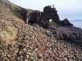
The cliff formations are the result of erosion along the sea coast. They are formed by the erosion of Oolitic rock beds located to the west of the entrance to Loch Bay.[4] Reached via a road from the Carsaig Pier, the track is strewn with volcanic rocks and boulders and involves about 4 miles of climbing to reach it.
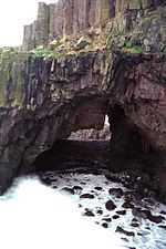
The first arch is visible at the end of the trek while descending from the ridge and looks as if it is opening in to the sea and the second one is hidden. The openings created by sea wave action are likened to cave entrances that "lead to another planet."[5] They are approachable mostly during low tides and should be viewed from a safe angle.[6] Of the two arches seen below the cliff, one is like a railway tunnel "deep and dark" and the other rises high and overlain by debris which is conjectured as being of an earlier collapsed arch.[7] One of the formations is a pyramidal mass of rock, perforated through the middle by an unusually shaped arch (called the "keyhole"[1]), and surmounted by the solitary shaft of a basaltic pillar. Another arch ("tunnel") is massive, with columnar basalts appearing to hang from the top.[1]) It is 20 metres (66 ft) in height over a length of 43 metres (141 ft) with a width of 20 metres (66 ft). Wild goats, golden eagles, breeding fulmars, and kittiwakes frequent the area.[6]
Gallery

References
- ↑ 1.0 1.1 1.2 Lonely Planet; Neil Wilson (2012). Lonely Planet Scotland's Highlands & Islands. Lonely Planet. pp. 127–. ISBN 978-1-74220-688-2.
- ↑ Great Britain. Hydrographic Dept (1911). West Coast of Scotland Pilot. Hydrographic Department, Admiralty. pp. 166–.
- ↑ Wilson, Neil; Murphy, Alan (2010). Scotland. Lonely Planet. pp. 307–. ISBN 978-1-74220-374-4.
- ↑ James W. Miller (1877). Miller's royal tourist handbook to the Highlands and Islands. pp. 5–.
- ↑ Mull, Iona and Staffa. Frances Lincoln Ltd. 2011. pp. 49–. ISBN 978-0-7112-2902-0.
- ↑ 6.0 6.1 Marsh, Terry (2011). The Isle of en Mull. Cicerone Press Limited. pp. 153–. ISBN 978-1-84965-389-3.
- ↑ Roger Redfern (1998). Walking in the Hebrides. Cicerone Press Limited. pp. 72–. ISBN 978-1-85284-263-5.
Coordinates: 56°17′35″N 6°03′09″W / 56.293108°N 6.052436°W
| ||||||||||||||||||||||||||||
