Carruthers Peak
| Carruthers Peak | |
|---|---|
|
Carruthers Peak from the south | |
| Elevation | 2,145 m (7,037 ft) |
| Prominence | 80 m (260 ft)(approx) |
| Location | |
| Location | New South Wales, Australia |
| Range | Main Range / Great Dividing Range |
| Coordinates | 36°24′31″S 148°17′28″E / 36.40861°S 148.29111°E |
| Topo map | NSW Department of Lands Perisher Valley |
| Climbing | |
| Easiest route | walk (track) |
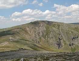
Carruthers Peak is a mountain in the Snowy Mountains between Mount Lee and Mount Twynam. It was named after NSW Premier Joseph Carruthers, who facilitated the building of the Summit Road to Mount Kosciuszko. It can be easily accessed, with the Main Range walk going straight up it.
The area around it contains patches of the rare windswept feldmark ecotope. Due to a century of grazing on the Main Range, the area around it was heavily eroded. From the 1950s Soil Conservation Service undertook an extensive program of rehabilitation of the vegetation of the Carruthers Peak–Mount Twynam area using bitumen, wire netting and bales of straw.[1] It lies on a vein of shale running south-southeast through the predominant granite.
See also
References
- ↑ None of these methods were very effective. However, by chance the bales of hay carried sheep sorrel which held the soil together for the recolonisation of native plants.
- Geehi Bushwalking Club, (2001) 8th ed. Snowy Mountains Walks, Canberra: National Capital Printing. ISBN 0-9599651-4-9