Carrollton Township, Carroll County, Missouri
| Carrollton Township | |
|---|---|
| Township | |
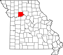
 Location in Carroll County | |
| Coordinates: 39°22′06″N 093°29′36″W / 39.36833°N 93.49333°WCoordinates: 39°22′06″N 093°29′36″W / 39.36833°N 93.49333°W | |
| Country | United States |
| State | Missouri |
| County | Carroll |
| Area | |
| • Total | 35.59 sq mi (92.17 km2) |
| • Land | 35.51 sq mi (91.98 km2) |
| • Water | 0.07 sq mi (0.19 km2) 0.21% |
| Elevation | 738 ft (225 m) |
| Population (2000) | |
| • Total | 4,355 |
| • Density | 122.6/sq mi (47.3/km2) |
| GNIS feature ID | 0766405 |
Carrollton Township is one of twenty townships in Carroll County, Missouri, USA. As of the 2000 census, its population was 4,355.
Geography
Carrollton Township covers an area of 35.59 square miles (92.2 km2) and contains one incorporated settlement, Carrollton (the county seat). According to the USGS, it contains three cemeteries: Mount Zion, Saint Marys and Willis Chapel.
The stream of Cottonwood Branch runs through this township.
References
External links
| |||||||||||||||||||||||||