Caroline Islands
Coordinates: 06°03′N 147°05′E / 6.050°N 147.083°E


The Caroline Islands (Islas Carolinas in Spanish, Karolinen in German) are a widely scattered archipelago of tiny islands in the western Pacific Ocean, to the north of New Guinea. Politically they are divided between the Federated States of Micronesia in the eastern part of the group, and Palau at the extreme western end. Historically, this area was also called Nuevas Filipinas or New Philippines[1] as they were part of the Spanish East Indies and governed from Manila in the Philippines.
Description
The group consists of about 500 small coral islands, east of the Philippines, in the Pacific Ocean; the distance from Manila to Yap, one of the larger islands of the group, is 1,200 miles (1,900 km).
Most of the islands comprise low, flat coral atolls, but some rise high above sea level.
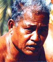
People and culture
.jpg)
The native inhabitants speak a variety of Micronesian languages including Pohnpeian, Chuukese, Carolinian, Yapese, and Kosraean, as well as the Western Malayo-Polynesian language Palauan. Other significant populations include Filipinos and Japanese.
The natives live mainly on horticulture and fishing, also supplementing their diet with many different varieties of bananas and taro, either of the "swamp" or "purple" varieties. On some islands housing continues to be built with local materials including coconut thatch. The language spoken in commerce is English, but there are several indigenous languages. They traditionally believe in a Supreme Being (Yalafar) and in a bad spirit (Can), yet they have hardly any religious rites. Due to extensive missionary work, Christianity is the primary religion practiced in this region of Micronesia.
Master Micronesian Navigator Mau Piailug was from the Carolinian island of Satawal. He learned the traditional navigation techniques of the Weriyeng school. These techniques had been preserved while similar techniques had been forgotten elsewhere partly due to the remoteness of the Carolinian Islands. In the 1970s Mau shared his knowledge with the Polynesian Voyaging Society which led to a revival of traditional Polynesian navigation and a new anthropological understanding of the history of Polynesian and Micronesian peoples.
In 1985 a study was made of the origin of the sidereal compass used in the Caroline Islands.[2]
History
Different islands and island groups in the Carolines passed down unique and variant oral legends recounting the origins and early histories of their peoples. On Pohnpei, for example, pre-colonial history is divided into three eras: Mwehin Kawa or Mwehin Aramas (Period of Building, or Period of Peopling, before ca. 1100); Mwehin Sau Deleur (Period of the Lord of Deleur, ca. 1100[3] to ca. 1628);[note 1] and Mwehin Nahnmwarki (Period of the Nahnmwarki, ca. 1628 to ca. 1885).[4][7] Pohnpeian legend recounts that the Saudeleur rulers, the first to bring government to Pohnpei, were of foreign origin. The Saudeleur centralized form of absolute rule is characterized in Pohnpeian legend as becoming increasingly oppressive over several generations. Arbitrary and onerous demands, as well as a reputation for offending Pohnpeian deities, sowed resentment among Pohnpeians. The Saudeleur Dynasty ended with the invasion of Isokelekel, another semi-mythical foreigner, who replaced the Saudeleur rule with the more decentralized nahnmwarki system in existence today.[9][10][11]
From the Moluccas, carried eastward by a storm, the Portuguese navigators Diogo da Rocha and Gomes de Sequeira reached some islands of the Archipelago in 1525.[12] It took about five stopovers by five different European ships before the name "Islas de Carolina" was used to refer to the stretch of islands located south of Guam. The name gained currency when in 1686, a Spaniard by the name of Francisco Lazcano named them after King Charles II of Spain or Carlos II, who funded the expedition.
Some few Western travelers subsequently visited the islands. An early visit of Spanish missionaries (1732) resulted in one of several murderous attacks on the newcomers. By 1875 Spain asserted her rights on the archipelago, claimed as early as the 17th century. The Caroline Islands were subsequently placed under the Spanish East Indies, administered from the Philippines. Germany, which had occupied Yap, disputed the Spanish claim, and the matter went to the arbitration of Pope Leo XIII in 1885. He decided in favor of Spain based on earlier claim and discovery, and offered Germany some trading rights. The Spanish did not settle the islands until 1886.[13] when they founded Santiago de la Ascension also known then as La Colonia (meaning "the colony"), known today known as Kolonia on the island of Pohnpei.
Then in 1899 in the German–Spanish Treaty (1899),[14][15] as a consequence of the Spanish–American War of 1898, Spain sold the islands to Germany for 25,000,000 pesetas or respectively 17 million goldmark (nearly 1,000,000 pounds sterling), which administered them as Karolinen, administratively associated with German New Guinea.
Japan occupied the islands in 1914. This occupation was carried out by two naval squadrons: the Western Caroline from that commanded by Rear Admiral Matsumura Tatsuo (1868–1832), the Eastern Caroline from Vice-Admiral Yamaya Tanin (1866–1940). Japan received a League of Nations mandate over them and the Marshall Islands in 1920. During World War II, Japan had a large base at Truk Lagoon, which the Allies effectively neutralized in Operation Hailstone. After the war, the islands (together with the Marshall Islands) became trust territories of the United States, with the Federated States of Micronesia gaining independence in 1986, followed by Palau in 1994.
Colonial governors or officers

District officers (from 1889, styled Bezirksamtmann):
In the western Caroline islands (Yap and Palau [and from 1907 Saipan])
- 29 June 1886 – 18??, Manuel de Elisa
- before November 1897 – after November 1898, S. Cortes
- 1899–1909, Arno Senfft (b. 1864 – d. 1909)
- 1909–19??, Rudolf Karlowa
- 1909–1910, Georg Fritz
- 1910–1911, Hermann Kersting
- 1911–1914, Baumert
In the Eastern Caroline islands (Ponape, and including the Marshall Islands from 1911)-
- June 1886 – 1887 Capriles
- 14 March 1887 – 1887, Isidro Posadillo (d. 1887)
- October 1887 – January 1891, Luis Cadarso y Rey (d. 1898)
- c.1894, Concha
- before November 1897 – after November 1898, J. Fernandez de Cordoba
- 12 October 1899 – August 1901, Albert Hahl (b. 1868 – d. 1945)
- 1 September 1901 – 30 April 1907, Victor Berg (b. 1861 – d. 1907)
- 1907–1908?, Max Girschner (acting)
- 1908–1909, Georg Fritz
- 1909 – 18 October 1910, Gustav Boeder (d. 1910)
- 1910 – 7 October 1914, August Überhorst
Ecclesiastical history
Two Jesuits, Juan Antonio Cantova (also known as John Anthony Cantova) and Victor Walter, attempted missionary work there in 1731; the former was soon murdered, the latter obliged to flee. Two other Jesuits were killed later. In 1767 the Jesuits were suppressed in the Spanish dominions, and during the next 120 years there is no trace of a missionary.
The controversy between Germany and Spain concerning the possession of the Carolines having been settled by Pope Leo XIII in favour of Spain, the king directed Spanish Capuchins to the islands, 15 March 1886, and the Propaganda Fide officially established that mission, 15 May 1886, dividing it into two sections, named West and East Carolines respectively. Until then the islands had belonged ecclesiastically to the Vicariate Apostolic of Micronesia. The Spanish Capuchins had a catechism and prayer book printed in the Ponape dialect, and Father Anthony of Valentia wrote a small grammar and dictionary of the Yap dialect in 1890.
When the Spanish Fathers had laid the foundations of the mission, these islands passed by purchase into the hands of Germany in 1899. Spain had contributed more than $5000 a year towards the mission; Germany granted no support. Spain had compelled the aborigines to send their children to school; Germany gave full liberty in this regard, and the people consequently began to neglect school as well as church. The mission thereby suffered greatly, and the Propaganda Fide finally deemed it advisable to replace the Spanish Capuchins with others of German nationality (7 November 1904) and to erect one Apostolic prefecture instead of the two separate missions (18 December 1905). The Very Reverend Father Venantius of Prechtal, Germany was appointed first prefect Apostolic.
In 1906 twelve fathers and twelve brothers were working in thirteen stations, and several Sisters of St. Francis left Luxembourg to take charge of the ten schools, in which were 262 children. Ninety adult converts were the "harvest" of that year, and the Catholic population is given as 1900 among 11,600 unconverted natives and a few Protestants. The United States Government sent, 1 July 1905, a Jesuit from the observatory at Manila to erect a meteorological station on the island of Yap, of which station the Capuchin Father Callistus was appointed director. The origin of the East-Asiatic typhoons had been traced to these regions, and twice a day observations are made, and notice is frequently given to Manila by cable.

Postage stamps
During the period of German control, Germany issued postage stamps for the islands; see postage stamps and postal history of the Caroline Islands for more details.
Notes
See also
References
- ↑ William Henry Rosser (1870). North Pacific pilot: The seaman's guide to the islands of the North Pacific, with an appendix on the winds, weather, currents, &c., of the North and South Pacific. J. Imray. pp. 183–184. Retrieved 28 March 2011.
- ↑ M.D. Halpern (1985) The Origins of the Carolinian Sidereal Compass, Master's thesis, Texas A & M University
- ↑ Flood, Bo; Strong, Beret E.; Flood, William (2002). Micronesian Legends. Bess Press. pp. 145–7, 160. ISBN 1-57306-129-8. Retrieved 2012-01-01.
- ↑ 4.0 4.1 Hanlon, David L (1988). Upon a Stone Altar: A History of the Island of Pohnpei to 1890. Pacific Islands Monograph 5. University of Hawaii Press. pp. 13–25. ISBN 0-8248-1124-0. Retrieved 2012-01-01.
- ↑ Cordy, Ross H (1993). The Lelu Stone Ruins (Kosrae, Micronesia): 1978-81 Historical and Archaeological Research. Asian and Pacific Archaeology (10). Social Science Research Institute, University of Hawaii at Manoa. pp. 14, 254, 258. ISBN 0-8248-1134-8. Retrieved 2011-12-31.
- ↑ Morgan, William N (1988). Prehistoric Architecture in Micronesia. University of Texas Press. pp. 60, 63, 76, 85. ISBN 0-292-76506-1. Retrieved 2011-12-31.
- ↑ 7.0 7.1 Panholzer, Tom; Rufino, Mauricio (2003). Place Names of Pohnpei Island: Including And (Ant) and Pakin Atolls. Bess Press. pp. xiii, xii, 101. ISBN 1-57306-166-2. Retrieved 2011-12-31.
- ↑ Micronesica. University of Guam. 1990. pp. 92, 203, 277. Retrieved 2011-12-31.
- ↑ Ballinger, Bill Sanborn (1978). Lost City of Stone: The Story of Nan Madol, the "Atlantis" of the Pacific. Simon and Schuster. pp. 45–8. ISBN 0-671-24030-7. Retrieved 2011-12-31.
- ↑ Riesenberg, Saul H (1968). The Native Polity of Ponape. Contributions to Anthropology 10. Smithsonian Institution Press. pp. 38, 51. Retrieved 2012-01-01.
- ↑ Petersen, Glenn (1990). "Lost in the Weeds: Theme and Variation in Pohnpei Political Mythology" (PDF). Occasional Papers (Center for Pacific Islands Studies, School of Hawaiian, Asian & Pacific Studies, University of Hawaiʻi at Mānoa) 35: 34 et seq. Retrieved 2011-12-31.
|chapter=ignored (help) - ↑ Galvano, Antonio (1563). The Discoveries of the World from Their First Original Unto the Year of Our Lord 1555, issued by the Hakluyt Society (2004 ed.). Kessinger Publishing. p. 168. ISBN 0-7661-9022-6.
- ↑ "A New Chart of Part of the North Pacific Ocean Exhibiting the Various Straits, Islands, and Dangers". World Digital Library. Retrieved 11 February 2013.
- ↑ More information on the German-Spanish Treaty
- ↑ Caroline Islands Timeline
Bibliography
 This article incorporates text from a publication now in the public domain: Chisholm, Hugh, ed. (1911). Encyclopædia Britannica (11th ed.). Cambridge University Press.
- This article incorporates text from a publication now in the public domain: Herbermann, Charles, ed. (1913). Catholic Encyclopedia. Robert Appleton Company.
- Region Datasheet at World Statesmen.org
External links
| Wikimedia Commons has media related to Caroline Islands Archipelago. |
| ||||||||||||||||||||||||||