Carmarthenshire
 | |
| Geography | |
| Area - Total - % Water |
Ranked 3rd 2,395 km² ? % |
|---|---|
| County Town | Carmarthen |
| Largest Town | Llanelli |
| ISO 3166-2 | GB-CMN |
| ONS code | 00NU (ONS) W06000010 (GSS) |
| Demographics | |
| Population: - Total (2011) - Density |
Ranked 4th 183,800 Ranked 18th 75 / km² |
| Ethnicity | 99.4% White |
| Welsh language - Any skills |
Ranked 3rd 63.6% |
| Politics | |
 Carmarthenshire County Council www | |
| Control | TBA (council NOC) |
| MPs |
|
| AMs |
|
| MEPs | Wales |
| Carmarthenshire | |
|---|---|
| Area | |
| - 1831 | 606,331-acre (2,453.73 km2) |
| Population | |
| - 1831 | 100,740[1] |
| Density | |
| - 1831 | 0.2/acre |
| History | |
| - Succeeded by | Dyfed |
| Chapman code | CMN |
| Government |
Carmarthenshire County Council (1889-1974) |
| - HQ | Carmarthen |
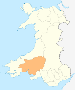
Carmarthenshire (Welsh: Sir Gaerfyrddin or Sir Gâr) is a unitary authority in the south west of Wales and the largest of the thirteen historic counties. The three largest towns are Llanelli, Carmarthen and Ammanford. The county town and administrative centre of Carmarthenshire is Carmarthen and the most populous settlement is the area in and around the town of Llanelli.
With its fertile land and agricultural produce, Carmarthenshire is known as the "Garden of Wales".[2]
History
Carmarthenshire has its early roots in the region formerly known as Ystrad Tywi (Vale of [the river] Tywi) and part of the Principality of Deheubarth during the High Middle Ages, with the court at Dinefwr.
Following the Edwardian Conquest of Wales, the region was reorganized by the Statute of Rhuddlan in 1284 into Carmarthenshire.
Carmarthenshire has been spelt in other ways in the past, including:
- Carmardenshire
- Caermarthenshire
- Caermardi / Caermardī
- Caermaridunum / Caermaridvnvm
Government
Carmarthenshire became an administrative county with a county council taking over functions from the Quarter Sessions under the Local Government Act 1888. Under the Local Government Act 1972, the administrative county of Carmarthenshire was abolished on 1 April 1974 and the area of Carmarthenshire became three districts within the new county of Dyfed : Carmarthen, Dinefwr and Llanelli. Under the Local Government (Wales) Act 1994, Dyfed was abolished on 1 April 1996 and the three districts united to form a unitary authority which had the same boundaries as the traditional county of Carmarthenshire. In 2003, the Clynderwen community council area was transferred to the administrative county of Pembrokeshire.
Geography
The county is bounded to the north by Ceredigion, to the east by Powys, Neath Port Talbot and Swansea, to the south by the Atlantic Ocean and to the west by Pembrokeshire. The surface generally is upland and mountainous. Fforest Fawr and Black Mountain extend into the east of the county and the Cambrian Mountains into the north. The south coast contains many fishing villages and sandy beaches. The highest point is Fan Brycheiniog, 2,631 feet (802 m). (although the main summit is in Powys). Carmarthenshire is the largest historic county by area in Wales.
It is drained by several important rivers, especially the Towy, which flows into the Bristol Channel, and its several tributaries, such as the River Cothi. The Towy is the longest river flowing entirely within Wales and is noted for its trout and salmon fishing. Other rivers include the Loughor (which forms the eastern boundary with Glamorgan), and the Gwendraeth Fawr.
Principal towns are Ammanford, Burry Port, Carmarthen, Kidwelly, Llanelli, Llandeilo, Newcastle Emlyn, Llandovery, St. Clears, Whitland and Pendine. The principal industries are agriculture, forestry, fishing and tourism. Although Llanelli is by far the larger town in the county, the county town remains in Carmarthen, mainly due to its central location.
Demography
Carmarthenshire has a population of 178,000.[3] According to the 2001 census, 39% of the population could speak, read, and write Welsh, and 64% were able to do at least one of the following: speak, read, or write Welsh, or understand the spoken language.[4]
Places of interest
Historical places


- Carreg Cennen Castle
- Dinefwr Castle
- Golden Grove
- Kidwelly Castle
- Laugharne Castle
- Llansteffan Castle
- Newton House
- Talley Abbey
- Laugharne home of Dylan Thomas.
Geography
- Afon Cywyn
- Afon Taf
- Afon Teifi
- Afon Tywi
- Aberglasney House and Gardens
- Black Mountain
- Brechfa Forest
- Carmel National Nature Reserve
- Cefn Sidan
- Loughor Estuary
- Millennium Coastal Park, Llanelli
- National Botanic Garden of Wales
- Pembrey Country Park
- Pendine Sands
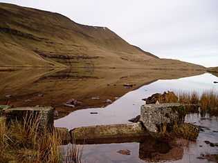
- Usk Reservoir
- WWT National Wetlands Centre, Llanelli
Museums
- Carmarthenshire County Museum
- Dolaucothi Gold Mines
- Dylan Thomas Boathouse
- Kidwelly Industrial Museum
- National Woollen Museum
- Parc Howard Museum
- Pendine Museum of Speed (Pendine)
- West Wales Museum of Childhood
Heritage railways
Sports venues
- Ffos Las racecourse - equestrian events
- Machynys - championship golf course
- Pembrey Circuit - motor sport
- Stradey Park - former Llanelli rugby union ground
- Parc y Scarlets - current Llanelli rugby union ground
- Carmarthen Velodrome
See also
- List of Lord Lieutenants of Carmarthenshire
- Custos Rotulorum of Carmarthenshire
- List of High Sheriffs of Carmarthenshire
- Carmarthenshire (UK Parliament constituency) for a list of MPs
- List of places in Carmarthenshire for an alphabetical list of towns and villages.
- Scheduled Monuments in Carmarthenshire
- List of schools in Carmarthenshire
- People from Carmarthenshire for a list of notable people from the county.
- Cuisine of Carmarthenshire
References
- ↑ "Census reports". A Vision of Britain through Time. Transcriber: David Allan Gatley (School of Social Sciences, University of Staffordshire). University of Portsmouth and others. 2009. Retrieved 6 January 2012.
- ↑ Visit Britain - Carmarthenshire
- ↑ "Population and Demography". Statistics and census information: Population and Demography. Carmarthenshire County Council. Retrieved 5 January 2012.
- ↑ "Welsh Language Statistics". Statistics and Census Information: Population and Demography. Carmarthenshire County Council. Retrieved 5 January 2012.
External links
- Carmarthenshire county council
- Carmarthenshire Official site from South West Wales Tourist Board
- Genuki: Research sources for Carmarthenshire
- Carmarthenshire at DMOZ
| ||||||||||||||||||||||||||
| ||||||
| ||||||||||||||||||||||||||||||||||||||
