Carlucet
| Carlucet | |
|---|---|
|
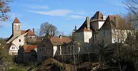
The church and surrounding buildings in Carlucet | |
 Carlucet | |
|
Location within Midi-Pyrénées region  Carlucet | |
| Coordinates: 44°43′20″N 1°36′48″E / 44.7222°N 1.6133°ECoordinates: 44°43′20″N 1°36′48″E / 44.7222°N 1.6133°E | |
| Country | France |
| Region | Midi-Pyrénées |
| Department | Lot |
| Arrondissement | Arrondissement of Gourdon |
| Canton | Canton of Gramat |
| Intercommunality | Communauté de communes du Pays de Gramat |
| Government | |
| • Mayor (2001–2008) | Brigitte Escapoulade |
| Area1 | 33.7 km2 (13.0 sq mi) |
| Population (2004)2 | 232 |
| • Density | 6.9/km2 (18/sq mi) |
| INSEE/Postal code | 46059 / 46500 |
| Elevation |
171–385 m (561–1,263 ft) (avg. 350 m or 1,150 ft) |
|
1 French Land Register data, which excludes lakes, ponds, glaciers > 1 km² (0.386 sq mi or 247 acres) and river estuaries. 2 Population without double counting: residents of multiple communes (e.g., students and military personnel) only counted once. | |
Carlucet is a commune in the Lot department in south-western France.
See also
| Wikimedia Commons has media related to Carlucet. |