Cappel, Moselle
| Cappel | ||
|---|---|---|
 | ||
| ||
 Cappel | ||
|
Location within Lorraine region  Cappel | ||
| Coordinates: 49°04′23″N 6°51′02″E / 49.0731°N 6.8506°ECoordinates: 49°04′23″N 6°51′02″E / 49.0731°N 6.8506°E | ||
| Country | France | |
| Region | Lorraine | |
| Department | Moselle | |
| Arrondissement | Arrondissement of Forbach | |
| Canton | Freyming-Merlebach | |
| Intercommunality | Communauté de communes de Freyming-Merlebach | |
| Government | ||
| • Mayor (2008–2014) | Hubert Bur | |
| Area1 | 5.97 km2 (2.31 sq mi) | |
| Population (2006)2 | 690 | |
| • Density | 120/km2 (300/sq mi) | |
| INSEE/Postal code | 57122 / 57450 | |
| Elevation |
232–301 m (761–988 ft) (avg. 297 m or 974 ft) | |
|
1 French Land Register data, which excludes lakes, ponds, glaciers > 1 km² (0.386 sq mi or 247 acres) and river estuaries. 2 Population without double counting: residents of multiple communes (e.g., students and military personnel) only counted once. | ||
.svg.png)
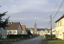
Cappel is a commune in the Moselle department in Lorraine in north-eastern France.
The village is situated on the N56 road.