Capen Street (MBTA station)
CAPEN ST | |||||||||||
|---|---|---|---|---|---|---|---|---|---|---|---|
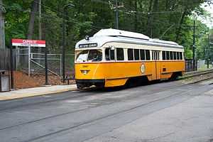 Trolley at the outbound platform at Capen Street | |||||||||||
| Location |
Capen Street off Eliot Street Milton, MA | ||||||||||
| Coordinates | 42°16′03″N 71°05′15″W / 42.267622°N 71.087436°WCoordinates: 42°16′03″N 71°05′15″W / 42.267622°N 71.087436°W | ||||||||||
| Line(s) | |||||||||||
| Platforms | 2 side platforms | ||||||||||
| Tracks | 2 | ||||||||||
| Construction | |||||||||||
| Disabled access | Yes | ||||||||||
| History | |||||||||||
| Opened | August 26, 1929 | ||||||||||
| Rebuilt | June 24, 2006 – December 22, 2007 | ||||||||||
| Traffic | |||||||||||
| Passengers (2010) | 58 (weekday inbound average)[1] | ||||||||||
| Services | |||||||||||
| |||||||||||
Capen Street (signed as Capen St) is a station on MBTA's Ashmont–Mattapan High Speed Line, a branch of the Red Line. The station is located on Capen Street off Eliot Street in Milton, Massachusetts. The station opened on August 26, 1929, as did the rest of the line. On June 24, 2006, it closed for a yearlong renovation of the Ashmont-Mattapan High Speed Line. Capen Street reopened on December 22, 2007, along with the rest of the line.[2]
Services
Capen Street serves the town of Milton, Massachusetts, and is the westernmost MBTA station within the town. The station is at grade level and is adjacent to the Capen Street grade crossing. From Capen Street, passengers can travel outbound to the Mattapan neighborhood of Boston or inbound to Ashmont where they can transfer to the heavy-rail portion of the Red Line and travel to other areas of Boston.
Capen Street consists of two side platforms which serve the Ashmont-Mattapan High Speed Line's two tracks. The platforms are staggered to allow trains to make the stop at Capen Street before crossing the street itself, as there is no signal at the grade crossing.[3] Capen Street is wheelchair accessible via wooden ramps on both platforms. A small shelter is located on the inbound platform. Capen Street has no fare controls, and fares from the station are paid on the train.
Signage
Capen Street had red signage up until the Ashmont–Mattapan Line's closure for renovation in 2006.[4] When the station reopened in 2007, green signage had been installed at the station as well as the other stations on the line, contrary to the MBTA's practice of color-coding signage to match the line.[5] However, in 2008 the green signage was replaced with red signage to match the line's color.[6]
References
- ↑ "Ridership and Service Statistics" (PDF). Massachusetts Bay Transportation Authority. 2010. Retrieved 14 January 2012.
- ↑ Belcher, Jonathan (12 November 2012). "Changes to Transit Service in the MBTA district" (PDF). NETransit. Retrieved 16 December 2012.
- ↑ O'Regan, Gerry and Pickering, Bob (2012). "MBTA Mattapan–Ashmont Line". NYCsubway.org. Retrieved 16 December 2012.
- ↑ Carter, Derek (8 April 2004). "3260, inbound to Ashmont". Mattapan High Speed Trolley. Retrieved 16 December 2012.
- ↑ Carter, Derek (22 December 2007 April 2004). "The new station signs are green". Mattapan High Speed Trolley. Retrieved 16 December 2012. Check date values in:
|date=(help) - ↑ Donovan, Aaron (11 July 2008). "Capen Street Station". Flickr. Retrieved 16 December 2012.
External links
| ||||||||||||||||||||||||||||||||||||||||||||||||||||||||||