Cape Lopatka
Coordinates: 50°52′N 156°40′E / 50.87°N 156.67°E
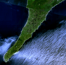
Cape Lopatka (Russian: мыс Лопатка) is the southernmost point of Kamchatka Peninsula, Russia, with the rural locality of Semenovka at its southernmost point. Cape Lopatka lies about 11 km (7 mi) north of Shumshu, the northernmost island of the Kuril Islands. Cape Lopatka also serves as the northernmost area of habitation by the Ainu people.
In 1737, Cape Lopatka's highest tsunami was recorded at 64 m (210 ft), washing over the peninsula.[1]
References
- ↑ Oracle Think Quest tsunamis : case studies Collected 3-Jul-2010.