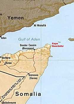
Cape Guardafui
| Cape Guardafui Ras Asir, Gardafuul راس عسير Aromata promontorium | |
|---|---|
|
Historic lighthouse on the extreme tip of Cape Guardafui. | |
 Cape Guardafui | |
| Country | |
| Region | Bari |
| Time zone | EAT (UTC+3) |

Cape Guardafui (Somali: Gees Gardafuul), also known as Ras Asir and historically as Aromata promontorium, is a headland in the autonomous Puntland region in Somalia. Coextensive with the Gardafuul administrative province, it forms the geographical apex of the Horn of Africa.
Location
Cape Guardafui is located at 11°49′N 51°15′E / 11.817°N 51.250°E, near the Gulf of Aden. The archipelago of Socotra lies off the cape in the Indian Ocean.[1]
15 leagues (45 miles) west of Guardafui is Ras Filuk, a steep cliff jutting into the Gulf of Aden from flatland. The mountain is believed to correspond with the ancient Elephas Mons or Cape Elephant (Ras Filuk in Arabic) described by Strabo.[2][3]
History
Referred to as Aromata promontorium by the ancient Greeks, Guardafui was described as early as the 1st century CE in the Periplus of the Erythraean Sea, along with other flourishing commercial settlements on the northern Somali littoral.[2]
In the early 19th century, Somali seamen barred entry to their ports along the coast, while engaging in trade with Aden and Mocha in adjacent Yemen using their own vessels.[2]
Due to consistent ship crashes along the coast, King Osman Mahamuud of the Majeerteen Sultanate, which controlled much of the northeastern Somali seaboard during the 19th century, entered into an informal agreement with Britain. The pact stipulated that the British would pay the King annual subsidies to protect shipwrecked British crews and guard wrecks against plunder. The agreement, however, remained unratified, as the British feared that doing so would "give other powers a precedent for making agreements with the Somalis, who seemed ready to enter into relations with all comers."[4]
Sultan Yusuf Ali Kenadid of the Sultanate of Hobyo, which also controlled a portion of the coast, later granted concessions to an Aden-based French hotel proprietor and a former French Army officer to construct a lighthouse in Cape Guardafui. Capital for the project was raised by a firm in Marseilles, but the deal subsequently fell through.[5]
At the turn of the 20th century, the Italian authorities in Italian Somaliland finally made good on the construction plans. A stone lighthouse and radio station were eventually built in the headland,[6] with the former named after Francesco Crispi in 1930.[7]
On April 8, 2013, the Puntland government announced the creation of a new region coextensive with Cape Guardafui named Gardafuul. Carved out of the Bari region, it consists of three districts and has its capital at Alula.
See also
References
- ↑ Longhurst, Alan R. (2007). Ecological Geography of the Sea (second ed.). Burlington, Massachusetts: Academic Press. pp. 297–298. ISBN 978-0-0804-6557-9. Retrieved April 28, 2015.
- ↑ 2.0 2.1 2.2 Tuckey, James Hingston, Commander, Royal Navy (1815). Maritime geography and statistics, or A description of the ocean and its coasts, maritime commerce, navigation, etc. Volume III. London: Printed for Black, Parry, and Co. p. 30. Retrieved April 28, 2015.
- ↑ Strabo (1889). The geography of Strabo: Literary translated, with notes. translated by Hans Claude Hamilton & William Falconer. Volumes 74-76 of Bohn's classical library. G. Bell & sons. p. 200.
- ↑ Laitin, David D. (1977). Politics, Language, and Thought: The Somali Experience. University Of Chicago Press. p. 71. ISBN 978-0-2264-6791-7.
- ↑ Committee on Northeast African Studies (1981). Northeast African Studies. Volume 3. Michigan State University Press. p. 50.
- ↑ Collier's Encyclopedia: With Bibliography and Index. Volume 9. New York: P.F. Collier & Son Corporation. 1957. p. 405.
- ↑ Bowditch, Nathaniel (1939). American Practical Navigator: An Epitome of Navigation and Nautical Astronomy. p. 352.
| ||||||||||||||||||||||||||||||||||||||||||||||||||||||||||