Cape Eluanbi
Coordinates: 21°54′08″N 120°51′10″E / 21.902222°N 120.852778°E
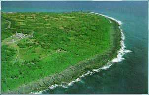
The Cape Eluanbi (Chinese: 鵝鑾鼻; pinyin: Éluánbí; Wade–Giles: O2-luan2-pi2; Pe̍h-ōe-jī: Gô-lôan-phīⁿ) is a cape in Hengchun Township, Pingtung County, Taiwan. It is the southernmost end of Central Mountain Range and part of Kenting National Park. It is also known as Ngoluanpi, Goa-loan-pi and South Cape. Facing the Luzon Strait and the Bashi Channel, it is the southernmost point of mainland Taiwan.
Name
The name Gô-lôan (Chinese: 鵝鑾; pinyin: Eluan) derives from Goran, the term for the noun "sail" in the Paiwan language of Paiwan people, one of the groups of Taiwanese aborigines. The word phīⁿ (Chinese: 鼻; pinyin: bi) means "nose", referring to the shape of a large stone in the nearby Banana Bay (香蕉灣). During Japanese rule, the name was usually written in katakana as ガランピ (Garambi) or in Kanji as 鵞鑾鼻.
Lighthouse
There is a lighthouse situated on Cape Eluanbi, called Eluanbi Lighthouse.