Cantagalo District
| Cantagalo | |
|---|---|
| District | |
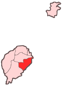 Location within São Tomé and Príncipe | |
| Coordinates: 0°13′N 6°42′E / 0.217°N 6.700°ECoordinates: 0°13′N 6°42′E / 0.217°N 6.700°E | |
| Country | São Tomé and Príncipe |
| Province/Island | São Tomé |
| Seat | Santana |
| Area | |
| • Total | 119 km2 (46 sq mi) |
| Population (2012 census) | |
| • Total | 18,194 |
| • Density | 150/km2 (400/sq mi) |
| Time zone | UTC (UTC+0) |
Cantagalo is a district of São Tomé Province. Out of the seven districts that make up the equatorial Atlantic islands of São Tomé and Príncipe. It is fourth largest in terms of population in 2004 and covers approximately 119 square kilometers. The district capital is Santana.
District Population History
- 1940 7,854 (12.9% of the national population)
- 1950 8,568 (14.2% of the national population)
- 1960 9,758 (15.2% of the national population)
- 1970 9,697 (13.1% of the national population)
- 1981 10,435 (10.8% of the national population)
- 1991 11,433 (9.7% of the national population)
- 2001 13,258 (9.6% of the national population)
International Relations
Cantagalo is twinned with:
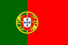 Viseu, Portugal
Other
Cantagalo has schools or collegiates (colegio), a lyceum (middle schools), a stadium, churches, beaches, a small port and a few squares (praças). The municipality is the middle-class in GDP and GNP in São Tomé and Príncipe.
| North: Mé-Zóchi | ||
| West: Mé-Zóchi and Caué | Cantagalo | East: Atlantic Ocean |
| South: Caué |
| ||||||||||||