Canning River (Alaska)
For the river in Australia, see Canning River (Western Australia).
| Canning River | |
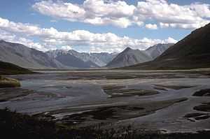 Confluence with Marsh Fork | |
| Country | United States |
|---|---|
| State | Alaska |
| Borough | North Slope |
| Source | Franklin Mountains |
| - location | Brooks Range |
| - elevation | 5,157 ft (1,572 m) [1] |
| - coordinates | 69°04′40″N 145°06′07″W / 69.07778°N 145.10194°W [2] |
| Mouth | Camden Bay |
| - location | Beaufort Sea |
| - elevation | 0 ft (0 m) [2] |
| - coordinates | 70°04′42″N 145°33′56″W / 70.07833°N 145.56556°WCoordinates: 70°04′42″N 145°33′56″W / 70.07833°N 145.56556°W [2] |
| Length | 125 mi (201 km) [2] |
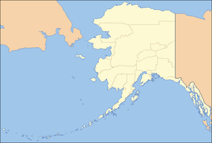 Location of the mouth of the Canning River in Alaska
| |
The Canning River flows through parts of the North Slope in the U.S. state of Alaska.[2] The river begins in the Franklin Mountains of the Brooks Range in the northeastern part of the state.[3] It flows generally north for 125 miles (201 km)[2] through the Arctic National Wildlife Refuge and enters Camden Bay west of Kaktovik on the Beaufort Sea.[3]
See also
| Wikimedia Commons has media related to Canning River, Alaska. |
References
- ↑ Source elevation derived from Google Earth search using GNIS source coordinates.
- ↑ 2.0 2.1 2.2 2.3 2.4 2.5 "Canning River". Geographic Names Information System. United States Geological Survey. March 31, 1981. Retrieved September 2, 2013.
- ↑ 3.0 3.1 Alaska Atlas & Gazetteer (7th ed.). Yarmouth, Maine: DeLorme. 2010. pp. 135–37. ISBN 978-0-89933-289-5.