Canillá
Coordinates: 15°10′00″N 90°51′00″W / 15.166667°N 90.85°W
| Canillá | |
|---|---|
| Municipality | |
|
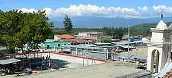
Canillá's central plaza in 2006 | |
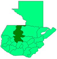
 Canillá Location in Guatemala | |
| Coordinates: 15°10′00″N 90°51′00″W / 15.16667°N 90.85000°W | |
| Country |
|
| Department |
|
| Municipality | Canillá |
| Government | |
| • Type | Municipal |
| Area | |
| • Municipality | 123 km2 (47 sq mi) |
| Elevation | 1,300 m (4,300 ft) |
| Population (Health Center Annual Report 2013)[1] | |
| • Municipality | 15,053 |
| • Urban | 2,198 |
| • Ethnicities | K'iche', Ladino |
| • Religions | Roman Catholicism, Evangelicalism, Maya |
| Climate | Am |
| Website | http://www.inforpressca.com/canilla/ |
Canillá is a municipality in the Guatemalan department of El Quiché with a surface area of 123 km2 and population 15,053 people.
People in Canillá speak Spanish, K'iche' (a Mayan language), or both. Primary religions are Catholic and Evangelical.
Economy
Canillá is an isolated city dependent on subsistence farming. Crops include corn, platanos, and other tropical fruits and vegetables. The small central city has the Municipal offices, a library, post office, and stores, including telephone services. Manufacturing includes brick making.
The main roads connecting Canillá to San Andrés Sajcabajá and Santa Cruz del Quiché, or Zacualpa and Joyabaj are unpaved and can be precarious in the rainy season. They suffer from erosion, potholes and landslides. Extreme caution is warranted. The poor state of the roads seriously limits Canillá's access to regional markets.
Employment opportunities in Canillá are few. Many people from Canillá travel for work, either to other areas of Guatemala, or to Mexico or the United States. One group from Canillá works in Tuscarawas County, Ohio.
Mayan Ruins at Chijoj, called "Los Cerritos"
Outside Canillá past the Aldea(village) Chijoj are the Mayan ruins,called "Los Cerritos." The name "Cerritos" is Spanish for "Little Hills." The ruins present several patters of pyramid, square and rectangle. It has a large sports field where Mayans used to play. It looks like a large swimming pool. The road from Canillá to Chijoj continues, in good weather, to the ruins.
-

The Mayan ruins at Chijoj
References
External links
- Official municipal page (Spanish)
- Richard Renner's 2004 photos of Canillá
- Richard Renner's 2006 photos of Canillá
![]() Media related to Canillá at Wikimedia Commons
Media related to Canillá at Wikimedia Commons
| |||||||||||||