Canet lo Roig
| Canet lo Roig | ||
|---|---|---|
| Municipality | ||
| ||
 Canet lo Roig Location in Spain | ||
| Coordinates: 40°33′03″N 0°14′33″E / 40.55083°N 0.24250°ECoordinates: 40°33′03″N 0°14′33″E / 40.55083°N 0.24250°E | ||
| Country |
| |
| Autonomous community |
| |
| Province | Castelló | |
| Comarca | Baix Maestrat | |
| Judicial district | Vinaròs | |
| Area | ||
| • Total | 68,7 km2 (265 sq mi) | |
| Elevation | 329 m (1,079 ft) | |
| Population (2009) | ||
| • Total | 882 | |
| • Density | 1.3/km2 (3.3/sq mi) | |
| Demonym | Canetà, canetana | |
| Time zone | CET (UTC+1) | |
| • Summer (DST) | CEST (UTC+2) | |
| Postal code | 12350 | |
| Official language(s) | Valencian | |

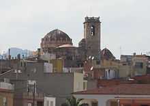
Church of Sant Michael; Canet lo Roig
Canet lo Roig (Valencian pronunciation: [kaˈned lo ˈrɔtʃ]) is a municipality in the comarca of Baix Maestrat in the Valencian Community, Spain.
The Serra de Sant Pere rises southeast of the town and the Cérvol River flows north of it. The Moles de Xert rise west of Canet, on the right side of the road between this town and Xert.
It is an agricultural town surrounded by cultivated plots, mainly almond, carob and olive trees, as well as some cereal fields.[1] The population of the town is under 900. Canet lo Roig is part of the Taula del Sénia free association of municipalities.
References
External links
| Wikimedia Commons has media related to Canet lo Roig. |
- Página web de Canet lo Roig
- Ple de l'Ajuntament Canet lo Roig
- Preguntes a l'ajuntament de Canet lo Roig
- Institut Valencià d'Estadística
- Portal de la Direcció General d'Administració Local de la Generalitat
| ||||||||