Canaro, Rovigo
| Canaro | |
|---|---|
| Comune | |
| Comune di Canaro | |
|
Santa Sofia, the Parish church, and the Town Hall | |
 Canaro Location of Canaro in Italy | |
| Coordinates: 44°56′N 11°40′E / 44.933°N 11.667°ECoordinates: 44°56′N 11°40′E / 44.933°N 11.667°E | |
| Country | Italy |
| Region | Veneto |
| Province | Rovigo (RO) |
| Frazioni | Baruchella, Boccalara, C. Benvenuto Tisi, C. Mella, C. Ruggieri, Ca' Matta, Croce del Sud, Crociara, Garofolo, Giaretta, La Frattina, Mezzavia, Paviole, Tenasi, Valiera, Vallone, Viezze |
| Area | |
| • Total | 32.7 km2 (12.6 sq mi) |
| Population (Dec. 2004) | |
| • Total | 2,885 |
| • Density | 88/km2 (230/sq mi) |
| Demonym | Canarini |
| Time zone | CET (UTC+1) |
| • Summer (DST) | CEST (UTC+2) |
| Postal code | 45034 |
| Dialing code | 0425 |
| Website | Official website |
.jpg)
Canaro is a comune (municipality) in the Province of Rovigo in the Italian region Veneto, located about 80 kilometres (50 mi) southwest of Venice and about 15 kilometres (9 mi) southwest of Rovigo. As of 31 December 2004, it had a population of 2,885 and an area of 32.7 square kilometres (12.6 sq mi).[1]
Geography
The municipality of Canaro contains the frazioni (subdivisions, mainly villages and hamlets) Baruchella, Boccalara, C. Benvenuto Tisi, C.Mella, C.Ruggieri, Ca' Matta, Croce del Sud, Crociara, Garofolo, Giaretta, La Frattina, Mezzavia, Paviole, Tenasi, Valiera, Vallone, and Viezze.
Canaro borders the following municipalities: Ferrara, Fiesso Umbertiano, Frassinelle Polesine, Occhiobello, Polesella and Ro.
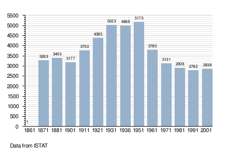
Demographic evolution
References
External links
![]() Media related to Canaro, Rovigo at Wikimedia Commons
Media related to Canaro, Rovigo at Wikimedia Commons