Camp Bonifas


Camp Bonifas was a United Nations Command military post located 400 meters south of the southern boundary of the Korean Demilitarized Zone.[2] It was 2,400 meters south of the military demarcation line and lies within the Joint Security Area (JSA), also known as Panmunjom. The Military Demarcation Line forms the border between South Korea (the Republic of Korea) and North Korea (the Democratic People's Republic of Korea). It was returned to the Republic of Korea in 2006.
Overview
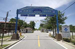
Camp Bonifas was home to the United Nations Command Security Battalion - Joint Security Area, whose primary mission was to monitor and enforce the Armistice Agreement of 1953 between North and South Korea. Republic of Korea and United States Forces Korea soldiers (known as "security escorts") conduct the United Nations Command DMZ Orientation Program tours of the JSA and surrounding areas. The camp has a gift shop which sells DMZ- and JSA-related souvenirs.
The camp, formerly known as Camp Kitty Hawk, was renamed on August 18, 1986, in honor of U.S. Army Captain Arthur G. Bonifas (posthumously promoted to major), who along with 1Lt. Mark T. Barrett (posthumously promoted to Captain), were killed by North Korean soldiers in the "Axe Murder Incident".
Access to the Neutral Nations Monitors (Sweden and Switzerland), on Camp Swiss-Swede, in through Camp Bonifas.
There is a par 3 one-hole "golf course" at the camp which includes an Astroturf green and is surrounded on three sides by minefields.[3] Sports Illustrated called it "the most dangerous hole in golf" and there are reports that at least one shot exploded a land mine.[3]
Kevin Sullivan of The Washington Post reported in 1998 that Camp Bonifas was a "small collection of buildings surrounded by triple coils of razor wire just 440 yards south of the DMZ" that, were it not for the minefields and soldiers, would "look like a big Boy Scout camp."[3]
References
- ↑ http://www.independent.co.uk/news/world/asia/the-ultimate-northsouth-divide-fore-welcome-to-the-worlds-most-dangerous-golf-course-443211.html
- ↑ Camp Bonifas (from globalsecurity.org)
- ↑ 3.0 3.1 3.2 "Sullivan, Kevin. "Borderline Absurdity A Fun-Filled Tour of the Korean DMZ." Washington Post 11 January 1998.
External links
![]() Media related to Camp Bonifas at Wikimedia Commons
Media related to Camp Bonifas at Wikimedia Commons
- www.facebook.com/usagrc, Camp Bonifas & Area I Facebook page
- redcloud.korea.army.mil, official website of USAG Area I, Camp Red Cloud, Camp Casey & Camp Bonifas, Korea
- The "Axe Murder Incident" and Operation Paul Bunyan, a Veterans of Foreign Wars organization website
- The World's Most Dangerous Golf Course