Cameron Corner
| Cameron Corner Bulloo Shire, Queensland | |||||||||||||
|---|---|---|---|---|---|---|---|---|---|---|---|---|---|
| Postcode(s) | 2880 | ||||||||||||
| LGA(s) | Bulloo Shire | ||||||||||||
| State electorate(s) | Warrego | ||||||||||||
| Federal Division(s) | Maranoa | ||||||||||||
| |||||||||||||


Cameron Corner is the point in the outback of eastern Australia where the boundary lines of the states of Queensland, South Australia, and New South Wales meet. It is also a locality in the Shire of Bulloo, Queensland (the area immediately to the north and east of the intersection of the state boundaries).[1] It is located about 1,400 kilometres (870 mi) west-southwest of Brisbane, Queensland. The noted Dingo Fence passes through Cameron Corner along the New South Wales border.
History
The corner and locality are named for the surveyor, John Brewer Cameron, from the New South Wales Lands Department, who spent two years during 1880 - 82 marking the border between New South Wales and Queensland.[1] Mr. Cameron erected a post there in September 1880 to mark its intersection with the border of South Australia. He placed a wooden marker every mile (1.6 km) eastwards along the interstate boundary.
This general area, which includes Sturt Stony Desert in the Lake Eyre Basin, was first explored by Captain Charles Sturt, who in 1844 went in search of a supposed inland sea in the center of Australia.
Facilities
According to the Brisbane Courier Mail newspaper in 2005, the sole permanent residents are Fenn and Cheryl Miller who operate the Cameron Corner Store and a golf course near there.[2] Apparently, it has a Queensland liquor licence with a New South Wales postal code and a South Australian telephone number."[3]
Events
New Year's Eve occurs three times a year in Cameron Corner (also in Poeppel Corner and Surveyor Generals Corner), because it's in the corner of three time zones.

Heritage listings
Cameron Corner is a heritage-listed site, being listed on the Queensland Heritage Register in 2012.[4]
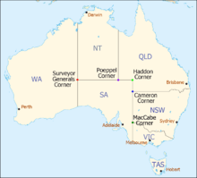
| Corners in Australia | |||||
|---|---|---|---|---|---|
| Name | Surveyor Generals | Poeppel | Haddon | Cameron | MacCabe |
| States | WA/NT/SA | NT/SA/Qld | SA/Qld | SA/Qld/NSW | SA/Vic/NSW |
References
- ↑ 1.0 1.1 "Cameron Corner (entry 42943)". Queensland Place Names. Queensland Government. Retrieved 16 May 2014.
- ↑ ABC staff (2 February 2007). "Remote golf course sees first ever grass". ABC online (Australian Broadcasting Corporation). Retrieved 2012-09-29.
- ↑ Cameron Corner, Qweekend, The Courier Mail 3–4 December 2005.
- ↑ "Cameron Corner (entry 33358)". Queensland Heritage Register. Queensland Heritage Council. Retrieved 2013-07-07.
| Wikimedia Commons has media related to Cameron Corner, South Australia. |
Coordinates: 28°59′56.7″S 140°59′58.1″E / 28.999083°S 140.999472°E