Calvert Island (British Columbia)
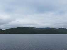
Calvert Island is an island on the coast of the Canadian province of British Columbia. It is located east of Queen Charlotte Sound in the Central Coast region, about 100 kilometres (62 mi) north of the town of Port Hardy, which is at the north end of Vancouver Island.
A number of smaller islands lie just north of Calvert Island, across Kwakshua Channel, the largest of which is Hecate Island. Hakai Passage separates the islands around Calvert Island from those around Hunter Island to the north. To the east Fitz Hugh Sound, part of the Inside Passage, separates Calvert Island from the mainland. The mouth of Rivers Inlet is east of the southern end of Calvert Island.
Calvert Island is 32 kilometres (20 mi) long and ranges in width from 3 kilometres (1.9 mi) to 16 kilometres (9.9 mi). It is 161 square kilometres (62 sq mi) in area. The island reaches 1,045 metres (3,428 ft) in elevation. Hecate Island is 44 square kilometres (17 sq mi) in area.[1]
Calvert Island was named in 1788 by Charles Duncan, captain of the fur trading vessel Princess Royal. The name probably honors the Calvert family, and perhaps specifically Lord Cecil Calvert, second Baron of Baltimore. The name was retained by George Vancouver and published as such on his maps.[2]
History
The traditional territory of the Heiltsuk included Calvert Island, and extended north along Dean Channel and Burke Channel, and along the coastal islands to Milbanke Sound. Archaeological evidence indicates many thousands of years of habitation in the region.[3]
In July, 1788, the British fur trader Charles Duncan arrived in the region of Calvert Island. He anchored his ship, the Princess Royal, in Milbanke Sound, then worked his way south, trading with the Heiltsuk and exploring what was then unknown waters to the British. He passed through Hakai Passage into Fitz Hugh Sound, then anchored on the east coast of Calvert Island in Safety Cove. After a brief stay he continued south to Vancouver Island.[4]
Protected areas
Just north of Calvert Island in Hakai Pass is the Hakai Luxvbalis Conservancy Area. At more than 1,200 square kilometres (300,000 acres) of land and sea, it is the largest provincial marine protected area on the British Columbia Coast.[5]
Hakai Provincial Recreation Area, 50,707 ha in size, includes the northern part of Calvert Island and the southern part of Hunter Island, as well as numerous smaller islands in the area.[6]
References
- ↑ Calvert Island, The Columbia Gazetteer of North America
- ↑ "Calvert Island". BC Geographical Names.
- ↑ Historical Notes on the Bella Bella Heiltsuk, The Heiltsuk Cultural Education Centre
- ↑ Galois, Robert (2004). Voyage to the Northwest Side of America: The Journals of James Colnett, 1786-89. University of British Columbia (UBC) Press. p. 17. ISBN 978-0-7748-0855-2. online at Google Books
- ↑ Hakai Luxvbalis Conservancy Area, Ministry of Environment
- ↑ Hecate Lowland Ecosection Summary, Integrated Land Management Bureau
External links
 Media related to Calvert Island (British Columbia) at Wikimedia Commons