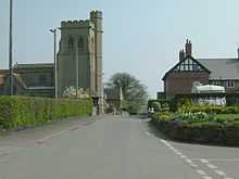
Calverhall
Calverhall is a small village in Shropshire, approximately 5 miles away from the town of Whitchurch. It lies within the civil parish of its neighbouring village of Ightfield which is one mile away.
Village life

Calverhall is the home of the renowned "Olde Jack Inn" public house/restaurant, named after a famed historical drinking vessel made of leather with a silver mounted enscripted band around the rim known as "the Jacorra" ("Corra" <core - ah> incidentally being an ancient name of the village). It was purported to be a challenge for any man to drink the full contents (just over a pint) of the Jacorra vessel in one go as quickly as possible but this was not as easy as it sounds due to the width of the vessel's rim only allowing a thin trickle to pour from it. Unfortunately the whereabouts of the fabled Jacorra are no longer known, and is believed to have disappeared without trace some 120 years ago.
The village has a long hunting history, it now lies within the North Shropshire Hunt's country, though the Cheshire Fox Hounds notably hunted the Shavington estate and it once lay within Sir Watkin Williams Wynn's hunting country.
Calverhall has also recently won a countywide community award, naming it the best village in Shropshire. It won praise for its improvement in recent years, due largely to a number of schemes, especially the Millennium Pond which sits either side of the road as an entrance way into the village from the Prees Road. It also boasts active sports and social groups, including cricket, tennis, bowls and a snooker/pool/recreation club, a much used village hall which caters for everything from local W.I. meetings, youth club nights and even touring local theatre groups - in fact, all in all it has more than some much larger villages. It does not however have a shop/post office which was lost a number of years ago, and was until 2002 served by the facility in neighbouring Ightfield before it too closed down and was converted into a private house.
Churches
Calverhall's church is the Church of England "Holy Trinity", which itself is part of a network of five local churches (Ash, Moreton Say, Ightfield, Calverhall, Adderley - abbr. AMICA) which are within a 6 mile diameter of each other and are served mainly by the Reverend Michael Last who resides in the rectory of nearby Moreton Say. The Amica Centre is the central administrative hub and a community centre for the AMICA Benefice, and is located in Ightfield, next to the church. The website is located at AmicaCentre.co.uk.
Housing
Housing in Calverhall falls into 3 main groups. There are (former) council houses, many of which are now privately owned. Secondly there are the "Corra Meadows" houses, these all being privately owned and are also the newest houses in the village, the development being built in the early 1990s. Also there are the oldest "Estate" houses, Calverhall falling within the boundaries of the Shavington and Cloverly estate, owned by the Heywood-Lonsdale family. The estate office is the village and was for many years run by Mr Timothy Heywood-Lonsdale before recently being passed onto his son, William.
Cloverley Hall

Cloverley Hall is a grade II* listed former Victorian country house which stands to the south-east of the village. It was originally built between 1864 and 1870 by architect William Eden Nesfield for Liverpool banker John Pemberton Heywood. In its original form it was unusual in having a great hall in a Victorian building but the main wing was demolished and rebuilt in 1926-7. It is constructed in two storeys to an L-shaped floor plan. [1] After the Second World War it was converted for use as a boys' school and since 1968 has been in use as a Christian Conference Centre. [2]
Notable People
- Clem Wilson, cricketer (1875-1944), who was twice Vicar (1910-12 and 1925 to his death) and died in the village.
References
- ↑ "Cloverley Hall and Stable Yards, Ightfield". British Listed Buildings. Retrieved 19 July 2013.
- ↑ "Cloverley Hall-Christian Conference Centre". Retrieved 19 July 2013.
Coordinates: 52°55′55″N 2°35′38″W / 52.932°N 2.594°W
External links
| Wikimedia Commons has media related to Calverhall. |