Callala Bay, New South Wales
| Callala Bay New South Wales | |||||||
|---|---|---|---|---|---|---|---|
|
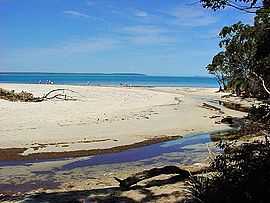
Wowly Gully in northern Callala Bay | |||||||
|
Callala Bay | |||||||
| Coordinates | 35°00′S 150°43′E / 35.000°S 150.717°ECoordinates: 35°00′S 150°43′E / 35.000°S 150.717°E | ||||||
| Population | 1,951 (2006)[1] | ||||||
| Postcode(s) | 2540 | ||||||
| Elevation | 13 m (43 ft) | ||||||
| Location |
| ||||||
| LGA(s) | City of Shoalhaven | ||||||
| State electorate(s) | South Coast | ||||||
| Federal Division(s) | Gilmore | ||||||
| |||||||
Callala Bay is a small town on the South Coast of New South Wales, Australia in the City of Shoalhaven.
The town is situated on the northern shore of Jervis Bay about 20 minutes drive from Nowra and 10 minutes from Culburra Beach. Callala Bay has an approximate elevation of 13 metres (43 ft) above sea level,[2] and is located inland from Callala Point, a headland facing the Tasman Sea.[3] Nearby settlements include Callala Beach to the south-west, Currarong to the south-east and Culburra Beach to the north-east. Local facilities include a safe harbour, jetty, sailing club, boat ramp, primary school and a small shopping centre. In 2006, the population of Callala Bay was 1,951.[1]
Sport and recreation
References
- ↑ 1.0 1.1 Australian Bureau of Statistics (25 October 2007). "Callala Bay (State Suburb)". 2006 Census QuickStats. Retrieved 2008-03-29.
- ↑ "Map of 35° 00.000' S 150° 43.250' E near Callala Bay". Retrieved 2008-03-29.
- ↑ "Callala Point (NSW)". Gazetteer of Australia online. Geoscience Australia, Australian Government.
External links
- Creating Callala ~ 2013 Strategic Plan
- Callala Beach Progress Association
- Callala Business Chamber & Tourism Inc.
- VISITNSW.com - Callala-Bay
| ||||||||||||||||||||||
| ||||||||||||||||||