California State Route 98
| ||||
|---|---|---|---|---|
|
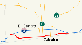
SR 98 highlighted in red | ||||
| Route information | ||||
| Defined by Streets and Highways Code § 398 | ||||
| Maintained by Caltrans | ||||
| Length: | 56.858 mi[1] (91.504 km) | |||
| Existed: | 1933[2] – present | |||
| Major junctions | ||||
| West end: |
| |||
|
| ||||
| East end: |
| |||
| Location | ||||
| Counties: | Imperial | |||
| Highway system | ||||
| ||||

State Route 98 (SR 98) is a state highway in the U.S. state of California. It is a bypass from Interstate 8 (I-8) running west to east south of the Interstate through the border city of Calexico. It passes through the city of Calexico and ends east of Holtville. The highway was added to the state highway system in 1933, and signed as Route 98 by 1938. The highway was paved and rerouted to its current path during the 1950s.
Route description
SR 98 begins at an interchange with I-8 southwest of the community of Ocotillo. The highway intersects CR S2 and passes south of Coyote Wells before turning due east through the Colorado Desert. After over forty miles of desert, SR 98 intersects with CR S29 and then CR S30, the latter in the community of Mount Signal. The road passes over the New River and intersects CR S31 before entering the border city of Calexico, just opposite from Mexicali, the capital of the Mexican state of Baja California. SR 98 intersects SR 111, the north-south highway connecting Mexicali and El Centro, before leaving the city and continuing east through rural Imperial County. After meeting SR 7, SR 98 goes through the community of Bonds Corner before intersecting CR S33. SR 98 then parallels the All American Canal before terminating at I-8 at Midway Well.[3]
The portion of SR 98 from SR 111 east to I-8 is designated as part of the Juan Bautista de Anza National Historic Trail auto tour route, promoted by the National Park Service.[4] SR 98 is not part of the National Highway System,[5] a network of highways that are essential to the country's economy, defense, and mobility.[6] In 2013, SR 98 had an annual average daily traffic (AADT) of 1,400 at the western terminus with I-8, and 26,500 between Rockwood Avenue and Heber Avenue in Calexico, the latter of which was the highest AADT for the highway.[7]
History
The highway was originally designated as Route 202 in 1933.[2] By 1934, a road headed due south from Seeley, before turning east through Calexico and curving slightly to the north and then east again through Bonds Corners. The easternmost portion of the highway was unpaved.[8] By 1938, the road from Coyote Wells east to the then-current routing had been constructed, but was a county road; the entirety of Route 98, which was signed, was either gravel or asphalt.[9] Between 1952 and 1954, the western portion of SR 98 was rerouted onto the county road, moving the western terminus to southwest of Coyote Wells; however, the new portion was not paved.[10][11] By 1956, the entire highway was paved.[12] In the 1964 state highway renumbering, the highway was officially renumbered as Route 98.[13] I-8 was extended to the western terminus of SR 98 by 1965,[14] and to the eastern terminus of SR 98 by 1970.[15]
Major intersections
Except where prefixed with a letter, postmiles were measured on the road as it was in 1964, based on the alignment that existed at the time, and do not necessarily reflect current mileage. R reflects a realignment in the route since then, M indicates a second realignment, L refers an overlap due to a correction or change, and T indicates postmiles classified as temporary (for a full list of prefixes, see the list of postmile definitions).[1] Segments that remain unconstructed or have been relinquished to local control may be omitted. The entire route is in Imperial County.
| Location | Postmile [1][7][16] | Destinations | Notes | ||
|---|---|---|---|---|---|
| R0.30 | Interchange; westbound exit and eastbound entrance; west end of SR 98 | ||||
| 1.52 | |||||
| 22.20 | |||||
| Mount Signal | |||||
| 30.27 | |||||
| Calexico | 32.31 | Former US 99 | |||
| 39.56 | |||||
| 43.68 | |||||
| 56.88 | Interchange; east end of SR 98 | ||||
| 1.000 mi = 1.609 km; 1.000 km = 0.621 mi | |||||
References
- ↑ 1.0 1.1 1.2 Staff. "State Truck Route List" (XLS FILE). California Department of Transportation. Retrieved March 1, 2015.
- ↑ 2.0 2.1 California State Assembly (1933). "An act...relating to...the addition of certain highways to the State system". Fiftieth Session of the Legislature. Statutes of California. State of California. Ch. 767.
- ↑ San Diego County Street Atlas (Map). Thomas Brothers. 2009.
- ↑ "Juan Bautista de Anza National Historic Trail Guide: Imperial County". National Park Service. Retrieved October 6, 2008.
- ↑ National Highway System: San Diego, CA (PDF) (Map). Federal Highway Administration. Retrieved August 9, 2012.
- ↑ Natzke, Stefan; Neathery, Mike & Adderly, Kevin (June 20, 2012). "What is the National Highway System?". National Highway System. Federal Highway Administration. Retrieved July 1, 2012.
- ↑ 7.0 7.1 Staff (2013). "All Traffic Volumes on CSHS". California Department of Transportation. Retrieved December 25, 2014.
- ↑ Road Map of California (Map). California Division of Highways. 1934. Retrieved October 29, 2014.
- ↑ Road Map of California (Map). California Division of Highways. 1938. Retrieved October 29, 2014.
- ↑ Road Map of California (Map). California Division of Highways. 1952. Retrieved October 29, 2014.
- ↑ Road Map of California (Map). California Division of Highways. 1954. Retrieved October 29, 2014.
- ↑ Road Map of California (Map). California Division of Highways. 1956. Retrieved October 29, 2014.
- ↑ California State Assembly (1963). "An act...relating to routes on the state highway system". 1963 Session of the Legislature. Statutes of California. State of California. Ch. 385.
- ↑ Staff (May 2, 1965). "Jacumba Grade Opens Tomorrow". The San Diego Union. p. A22. OCLC 13155544.
- ↑ Road Map of California (Map). California Division of Highways. 1970. Retrieved October 29, 2014.
- ↑ Staff (July 2007). "Log of Bridges on State Highways". California Department of Transportation. Retrieved April 11, 2009.
External links
Route map: Bing
- California @ AARoads.com - State Route 98
- Caltrans: Route 98 highway conditions
- California Highways: SR 98