California State Route 195
| ||||
|---|---|---|---|---|
 | ||||
| Route information | ||||
| Defined by Streets and Highways Code § 495 | ||||
| Maintained by Caltrans | ||||
| Length: | 7.420 mi[1] (11.941 km) | |||
| Major junctions | ||||
| West end: | Harrison Street (Old SR 86) near Oasis | |||
| East end: |
| |||
| Highway system | ||||
| ||||

State Route 195 (SR 195) is a state highway in the U.S. state of California, branching westward from State Route 111.
Route description
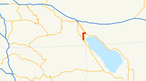
The route begins at Harrison Street (Old SR 86) in Riverside County. It then heads north as Pierce Street until intersecting 66th Street, where SR 195 turns east. The highway intersects State Route 86 and continues to the town of Mecca, where it meets its north end at State Route 111.[1][2]
History
SR 195 was designated in the 1964 state highway renumbering.[3] The original alignment began at Interstate 10 near Cottonwood Spring at the southern end of Joshua Tree National Park, passing Buried Mountain, and then through Box Canyon. The road crossed the San Andreas Fault at the southern end of Box Canyon, went through Mecca, before terminating at State Route 111 on the opposite side of the Salton Sea. This portion was removed in 1972. When the SR 86 freeway was fully constructed, SR 195 was supposed to be removed from the state highway system according to state law.[4]
Major intersections
Except where prefixed with a letter, postmiles were measured on the road as it was in 1964, based on the alignment that existed at the time, and do not necessarily reflect current mileage. R reflects a realignment in the route since then, M indicates a second realignment, L refers an overlap due to a correction or change, and T indicates postmiles classified as temporary (for a full list of prefixes, see the list of postmile definitions).[1] Segments that remain unconstructed or have been relinquished to local control may be omitted. The entire route is in Riverside County.
| Location | Postmile [1][5][6] | Destinations | Notes | ||
|---|---|---|---|---|---|
| R0.00 | Harrison Street | South end of SR 195; former US 99; former SR 86 | |||
| Mecca | 7.42 | North end of SR 195 | |||
| 1.000 mi = 1.609 km; 1.000 km = 0.621 mi | |||||
References
- ↑ 1.0 1.1 1.2 1.3 Staff. "State Truck Route List" (XLS FILE). California Department of Transportation. Retrieved March 1, 2015.
- ↑ Google (2011-01-02). "California State Route 195" (Map). Google Maps. Google. Retrieved 2011-01-02.
- ↑ California State Assembly (1963). "An act...relating to routes on the state highway system". 1963 Session of the Legislature. Statutes of California. State of California. Ch. 385.
- ↑ California State Assembly (1972). "An act to amend...the Streets and Highways Code, relating to state highways". 1972 Session of the Legislature. Statutes of California. State of California. Ch. 1216.
- ↑ California Department of Transportation, Log of Bridges on State Highways, July 2007
- ↑ California Department of Transportation, All Traffic Volumes on CSHS, 2005 and 2006
Route map: Bing