Calau
| Calau | ||
|---|---|---|
|
Town hall of Calau | ||
| ||
 Calau | ||
Location of Calau within Oberspreewald-Lausitz district  | ||
| Coordinates: 51°44′45″N 13°57′03″E / 51.74583°N 13.95083°ECoordinates: 51°44′45″N 13°57′03″E / 51.74583°N 13.95083°E | ||
| Country | Germany | |
| State | Brandenburg | |
| District | Oberspreewald-Lausitz | |
| Government | ||
| • Mayor | Werner Suchner (Ind.) | |
| Area | ||
| • Total | 162.59 km2 (62.78 sq mi) | |
| Population (2012-12-31)[1] | ||
| • Total | 8,152 | |
| • Density | 50/km2 (130/sq mi) | |
| Time zone | CET/CEST (UTC+1/+2) | |
| Postal codes | 03205 | |
| Dialling codes | 03541 | |
| Vehicle registration | OSL, CA, SFB | |
| Website | www.calau.de/ | |


Calau (German pronunciation: [kaːlaʊ], Sorbian: Kalawa) is a small town in the Oberspreewald-Lausitz district, in southern Brandenburg, Germany. It is situated 14 km south of Lübbenau, and 27 km west of Cottbus. Calau is also called the home of the Kalauer.
Geography
The Town of Calau is situated in the middle of the Niederlausitz, about 27 km west of Cottbus at the eastern edge of the Lower Lusatian Ridge Nature Park as well as at the southern edge of the famous Spreewald.
The area around Calau is strongly characterized by former brown-coal-mining sites, which are valuable retreat areas for animals and plants nowadays. Many places are left to nature after recultivation, the Heinz-Sielmann-Stiftung adopted numerous areas, others are managed near-natural and sustainably by the "Landesforstverwaltung". Foresters offer walking tours through the region. Particularly the "Geologische und Naturlehrpfad Luttchensberg" is a sight to see.
Town subdivisions
- Stadt Calau
- Ortsteil Bolschwitz
- Ortsteil Buckow
- Ortsteil Craupe with Radensdorf and Schrakau
- Ortsteil Gollmitz with Settinchen
- Ortsteil Groß Jehser with Erpitz and Mallenchen
- Ortsteil Groß-Mehßow with Klein Mehßow
- Ortsteil Kemmen with Säritz und Schadewitz
- Ortsteil Mlode with Rochusthal
- Ortsteil Saßleben with Kalkwitz and Reuden
- Ortsteil Werchow with Cabel (Village) and Plieskendorf
- Ortsteil Zinnitz with Bathow (Village)
Population
There are only a few people with Sorbian roots living in Calau today, although the Sorbs were quite a large minority in 1843 with about 30.8 percent of the overall population. In following years the number of Sorbs decreased rapidly, and in 1900 only 3.5 percent of the population were Sorbs.
Demography
-

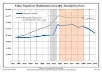
Development of Population since 1875 within the Current Boundaries (Blue Line: Population; Dotted Line: Comparison to Population Development of Brandenburg state; Grey Background: Time of Nazi rule; Red Background: Time of Communist rule)
-

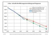
Recent Population Development (Blue Line) and Forecasts
|
|
|
|
Detailed data sources are to be found in the Wikimedia Commons.[4]
Politics
Municipal Assembly
The municipal assembly (Stadtverordnetenversammlung) consists of 18 "Stadtverordneten" plus the "Buergermeister" (town mayor).
- The Left: 6 seats
- Christian Democratic Union: 4 seats
- Social Democratic Party of Germany: 3 seats
- Free Voters: 2 seats
- Alliance '90/The Greens: 1 seats
- Free Democratic Party: 1 seat
- German Social Union: 1 seat
(Stand: Kommunalwahl am 28. September 2008)
International relations
Historical sites
- Memorial at the Karl-Marx-Straße/Ecke Parkstraße, 1928 initially dedicated to the first Reichspräsident Friedrich Ebert, destroyed by the Nazis in 1933, to be dedicated to the victims of National socialism in 1948, rededicated again in 1989 to the victims of Fascism and Stalinism
- Memorial for actor Joachim Gottschalk. When his Jewish wife Meta and son Michael were to be deported, the whole family decided to commit suicide on November 6, 1941. The bronze figure, which was created by Theo Balden in 1967, resembles the actor. It was initially located in a park but had to be moved due to the building of the local Sparkasse in the 1990s. Its new place is a memorial wall in the Joachim-Gottschalk-Straße 35.
Economy and infrastructure
The transmitter station Calau, which belongs to the Deutsche Telekom radiates a variety of VHF-and TV-programmes of the rbb for Brandenburg. Its radio mast is a reinforced concrete tower of 190 m height, the so-called "Langer Calauer", in the southwest of town. It was built in 1982.
Traffic
There are no "Bundesstrassen" going through Calau, the motorway junction Calau is seven km to the northwest at the A 13.
Calau is situated at the railroad lines Cottbus–Leipzig and Lübbenau–Senftenberg.
Edification
Schools
- Primary school Calau, named Carl-Anwandter-Grundschule since 2008
- Comprehensive school, named Robert-Schlesier-Schule since 2007
- Academic high school, named Carl-Anwandter-Gymnasium Calau (closed since 2008)
Personalities
- Dietrich von Bocksdorf (b. 1410 in Zinnitz – 1466 in Naumburg), bishop of Naumburg
- Erasmus Robert Freiherr von Patow (b. September 10, 1804 in Mallenchen, † January 5, 1890 in Berlin), Prussian politician
- Joachim Gottschalk (1904–1941), Actor
- Jean Pierre Vité (b. June 11, 1923 in Groß Jehser), forestry scientist
- Carl Anwandter (April 1, 1801 – July 10, 1889), stands out as leader of the first contingent of German colonists sent by Philippi; Anwandter is also founder of the German school Valdivia (Chile)
References
- ↑ "Bevölkerung im Land Brandenburg nach amtsfreien Gemeinden, Ämtern und Gemeinden 31. Dezember 2012 (XLS-Datei; 83 KB) (Einwohnerzahlen auf Grundlage des Zensus 2011)". Amt für Statistik Berlin-Brandenburg (in German). 31 December 2012.
- ↑ ...more at the german Wikipedia
- ↑ Boundaries as of 2013
- ↑ Population Projection Brandenburg at Wikimedia Commons
Bibliography
- Richard Moderhack: Die ältere Geschichte der Stadt Calau in der Niederlausitz, Dissertation 1932
External links
| Wikimedia Commons has media related to Calau. |
- Offiicial Website Calau.de
- Website about the Carl-Anwandter-Gymnasium
- Website Groß Mehßow
- Website Reuden
| ||||||||
