Caimanera
| Caimanera | |
|---|---|
| Municipality | |
 | |
.png) Caimanera municipality (red) within Guantánamo Province (yellow) and Cuba | |
 Location of Caimanera in Cuba | |
| Coordinates: 19°59′41″N 75°09′36″W / 19.99472°N 75.16000°WCoordinates: 19°59′41″N 75°09′36″W / 19.99472°N 75.16000°W | |
| Country |
|
| Province | Guantánamo |
| Area[1] | |
| • Total | 366 km2 (141 sq mi) |
| Elevation | 5 m (16 ft) |
| Population (2004)[2] | |
| • Total | 10,562 |
| • Density | 28.9/km2 (75/sq mi) |
| Time zone | EST (UTC-5) |
| Area code(s) | +53-21 |
Caimanera is a municipality and town in Guantánamo Province on the south eastern coast of Cuba. It is a fishing village and port built on the West shore of the sheltered Guantanamo Bay, just North of the US naval base and South of the provincial capital, Guantánamo.
History
The town was named for the alligators (Dutch: Kaaiman) which were once common in the river and in the mangrove labyrinths of the upper Bay, but which since declined in numbers.
The community of fishermen and salt mine workers flourished at the beginning of the 20th century precisely because of the base’s construction. It was a magnet for Cuban workers and a popular spot for visitors, including Cubans from across the island and people from nearby countries such as Jamaica.
Geography
Caimanera borders with the municipalities of Niceto Pérez, Guantánamo, Manuel Tames and San Antonio del Sur. Its territory includes the villages of Boquerón (also known as "Mártires de la Frontera"), Cayamo and Mata Abajo.
Residents of this remote town are the closest Cuban neighbours to the US military camp and currently prison for combatants from a war in Afghanistan. The North East Gate, located near Boquerón, is the only US-Cuban border crossing point.[3][4][5] Due to its proximity to the US Base Caimanera is a forbidden town needing a special permission from the government to visit it.[6]
Demographics
In 2004, the municipality of Caimanera had a population of 10,562.[2] With a total area of 366 km2 (141 sq mi),[1] it has a population density of 28.9/km2 (75/sq mi).
Economy
Ships chiefly export sugarcane and coffee.
Transport
Linked to Guantánamo by the "Carretera a Caimanera" road, the municipal territory of Caimanera is located close to the "Carretera Central". The town counts also a terminal station on a minor railway line to Guantánamo.
Gallery
-
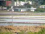
View of the town (1)
-
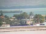
View of the town (2)
-
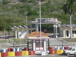
The "North East Gate" border crossing near Boquerón
-

Guantánamo River near Caimanera
See also
- Guantanamo Bay
- List of cities in Cuba
- Municipalities of Cuba
References
- ↑ 1.0 1.1 Statoids. "Municipios of Cuba". Retrieved 2007-10-05.
- ↑ 2.0 2.1 Atenas.cu (2004). "2004 Population trends, by Province and Municipality" (in Spanish). Archived from the original on 2007-09-27. Retrieved 2007-10-05.
- ↑ Article on Joint Task Force Guantanamo website
- ↑ Article on US Department of Defense website
- ↑ (Spanish) "The Naval Base in Caimanera" (EcuRed)
- ↑ "Cuba's Forbidden Towns" on the Havana Journal
External links
| Wikimedia Commons has media related to Caimanera. |
- (Spanish) Caimanera on EcuRed
- Google. "Caimanera". Google Maps. Google.