Caibaté
| Map | |
|---|---|
 | |
| Statistics | |
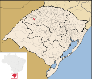
| State: | Rio Grande do Sul |
| Meso-region: | Northwestern Rio Grande do Sul (Noroeste Rio-Grandense) |
| Micro-Region: | Cerro Largo |
| Anniversary: | May 15 |
| Founded: | September 15, 1965 |
| Location: | 28.286/28° 17' 16" S lat. 54.635/54° 38' 16 W long. |
| Area: | 374.65 km² |
| Population (2003): - Total - Change - Density | 5,003 - 13.35/km² |
| Elevation: | 286 m |
| Postal code: | 97930-xxx |
| Name of inhabitants: | Caibateense |
| Website: | www.caibate.rs.gov.br |
| Politics | |
| Mayor: | --> |
Caibaté (Portuguese meaning Saint Nicholas) is a municipality of the state of Rio Grande do Sul, Brazil. The origin of the name comes from the Tupi language. It is located 524 km west of the state capital of Porto Alegre, northeast of Alegrete.
Bounding municipalities
Sporting club
- Spor Club Corsário
External links
- http://www.citybrazil.com.br/rs/caibate/ (Portuguese)
- Map and Aerial photos:
- Coordinates: 28°17′16″S 54°38′16″W / 28.28778°S 54.63778°W
- Street maps: Street map from Mapquest, MapPoint or Google
- Satellite images and Aerial photos: Google
