Cadbury Camp
| Cadbury Camp | |
|---|---|
|
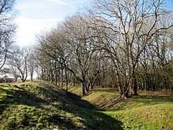
Tree growth on the ramparts at Cadbury Camp | |
| Location | Tickenham, Somerset, England |
| Coordinates | 51°26′45″N 2°47′12″W / 51.44583°N 2.78667°WCoordinates: 51°26′45″N 2°47′12″W / 51.44583°N 2.78667°W |
| Built | Iron Age |
| Official name: Cadbury Camp | |
| Designated | 17 October 1930[1] |
| Reference no. | 1008295 |
 Location of Cadbury Camp in Somerset | |
Cadbury Camp is an Iron Age hill fort in Somerset, England, near the village of Tickenham. It has been designated as a scheduled monument.[1][2]
Although primarily known as a fort during the Iron Age it is likely, from artefacts discovered at the site, that it was first used in the Bronze Age and still occupied through the Roman era into the Anglo-Saxon period.
The hill fort is well preserved, and is managed by the National Trust through a Higher Level Stewardship agreement with Natural England which involves tree clearing and management of the scrub.
History
The name Cadbury is derived from Cada's fort.[3][4]
The hill fort was constructed during the Iron Age, probably by the local Dobunni tribe, however the details are not fully known. The discovery of a bronze spear or axe head at the site indicates use before the Iron Age.[3][1] The Bronze Age spearhead is in the Museum of Somerset in Taunton.[2]
Hill forts developed in the Late Bronze and Early Iron Age, roughly the start of the first millennium BC.[5] The reason for their emergence in Britain, and their purpose, has been a subject of debate. It has been argued that they could have been military sites constructed in response to invasion from continental Europe, sites built by invaders, or a military reaction to social tensions caused by an increasing population and consequent pressure on agriculture. The dominant view since the 1960s has been that the increasing use of iron led to social changes in Britain. Deposits of iron ore were located in different places to the tin and copper ore necessary to make bronze, and as a result trading patterns shifted and the old elites lost their economic and social status. Power passed into the hands of a new group of people.[6] Archaeologist Barry Cunliffe believes that population increase still played a role and has stated "the forts provided defensive possibilities for the community at those times when the stress of an increasing population burst out into open warfare. But I would not see them as having been built because there was a state of war. They would be functional as defensive strongholds when there were tensions and undoubtedly some of them were attacked and destroyed, but this was not the only, or even the most significant, factor in their construction".[7]
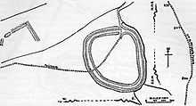
The fort, which covers about 7 acres (2.8 ha),[2] consisted of ditches and earth banks topped with a wooden fence in an elevated position above the marshy land below.[3] It extends approximately 190 metres (620 ft) from north to south and 160 metres (520 ft) from east to west. The ditch is around 2 metres (6 ft 7 in) deep and the ramparts rise up around 1.5 metres (4 ft 11 in).[1]
After the Iron Age occupation may have continued into the Roman era indicated by the discovery of coins, a small stone statue of Mars possibly from a Roman temple and a brass of Claudius Gothicus.[3][1] The site may still have been occupied into the Anglo-Saxon period.[3] Several of the finds were uncovered during excavations by Harold St George Gray in 1922, however the coin dating from around 370 was discovered in 1945 and a Romano-British relief in the inner defensive ditch in 1974.[2]
Location
Cadbury Camp is situated on a natural ridge between the Gordano Valley and the North Somerset Levels, next to the Limebreach Wood ancient woodland and nature reserve.
Current management
The site was once part of the estate linked to Clevedon Court.[8] It is now managed via a Higher Level Stewardship agreement between the National Trust and Natural England.[9] This has involved removing trees whose roots are growing into the earthen banks of the site. In particular non native Turkey Oaks, which provide a habitat for damaging Gall wasps, are being removed. Cattle are also being used to manage the scrub and encourage the growth of flowers such as orchids.[9]
Myths and legends
Local legends associate it with Arthurian England and Camelot, though these may be due to confusion with the better-known Cadbury Castle, near South Cadbury some 50 miles to the south.[10]
Panoramic view

See also
- List of hill forts and ancient settlements in Somerset
- List of National Trust properties in Somerset
References
- ↑ 1.0 1.1 1.2 1.3 1.4 "Cadbury Camp, a small multivalate hillfort on Cadbury Hill". National Heritage List for England. Historic England. Retrieved 26 April 2015.
- ↑ 2.0 2.1 2.2 2.3 "Cadbury Camp". National Monument Record. English Heritage. Retrieved 21 December 2013.
- ↑ 3.0 3.1 3.2 3.3 3.4 "The Iron Age past of Cadbury Camp". National Trust. Retrieved 21 December 2013.
- ↑ "Clambering overCadbury Camp" (PDF). North Somerset Council. Retrieved 21 December 2013.
- ↑ Payne, Andrew; Corney, Mark; Cunliffe, Barry (2007). The Wessex Hillforts Project: Extensive Survey of Hillfort Interiors in Central Southern England. English Heritage. p. 1. ISBN 978-1-873592-85-4.
- ↑ Sharples, Niall M (1991). English Heritage Book of Maiden Castle. London: B. T. Batsford. pp. 71–72. ISBN 0-7134-6083-0.
- ↑ "Time Team: Swords, skulls and strongholds". Channel 4. 19 May 2008. Retrieved 16 September 2009.
- ↑ "Cadbury Camp". National Trust. Retrieved 21 December 2013.
- ↑ 9.0 9.1 "Cadbury Camp — our work". National Trust. Retrieved 21 December 2013.
- ↑ Reno, Frank D. (2007). The Historic King Arthur: Authenticating the Celtic Hero of Post-Roman Britain. McFarland & Co Inc. p. 206. ISBN 978-0786430253.
External links
| Wikimedia Commons has media related to Cadbury Camp. |