Cachoeira do Sul
| Cachoeira do Sul | ||
|---|---|---|
| Municipality | ||
|
Catedral Nossa Senhora da Conceição | ||
| ||
| Nickname(s): Capital Nacional do Arroz "National Rice Capital" | ||
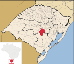 Location within Rio Grande do Sul | ||
| Coordinates: 30°02′21″S 52°53′38″W / 30.03917°S 52.89389°WCoordinates: 30°02′21″S 52°53′38″W / 30.03917°S 52.89389°W | ||
| Country | Brazil | |
| Region | South | |
| State | Rio Grande do Sul | |
| Founded | 1820 | |
| Government | ||
| • Mayor | Neiron Viegas (PT) | |
| Area | ||
| • Total | 3,715 km2 (1,434 sq mi) | |
| Elevation | 68 m (223 ft) | |
| Population (2006 est.) | ||
| • Total | 89,669 | |
| • Density | 24/km2 (63/sq mi) | |
| Time zone | UTC-3 (UTC-3) | |
| • Summer (DST) | UTC-2 (UTC-2) | |
| Website | cachoeiradosul.rs.gov.br | |


Cachoeira do Sul is a municipality of the state of Rio Grande do Sul, Brazil.
It is located at a latitude of 30º02'21" S and a longitude of 52º53'38" W, at an approximate height of 68 meters over sea level. Its population in 2004 was approximately 89120 and its surface area is 3715.5 square kilometers.
