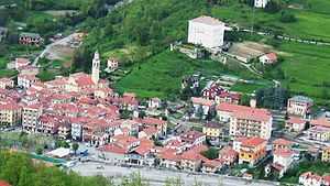
Cabella Ligure
| Cabella Ligure | |
|---|---|
| Comune | |
| Comune di Cabella Ligure | |
 | |
 Cabella Ligure Location of Cabella Ligure in Italy | |
| Coordinates: 44°40′N 9°5′E / 44.667°N 9.083°ECoordinates: 44°40′N 9°5′E / 44.667°N 9.083°E | |
| Country | Italy |
| Region | Piedmont |
| Province | Province of Alessandria (AL) |
| Frazioni | Centrassi, Casella, Cornareto, Pobbio Inf. e Pobbio Sup., Selvagnassi, Teo, Piuzzo, Cornareto, Rosano, Dovanelli, Cremonte, Piancerreto, Serasso, Dova Inferiore, Dova Superiore, Cosola, Capanne di Cosola, Guazzolo |
| Area | |
| • Total | 46.8 km2 (18.1 sq mi) |
| Elevation | 510 m (1,670 ft) |
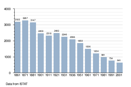
| Population (Dec. 2004) | |
| • Total | 603 |
| • Density | 13/km2 (33/sq mi) |
| Demonym | Cabellesi |
| Time zone | CET (UTC+1) |
| • Summer (DST) | CEST (UTC+2) |
| Postal code | 15060 |
| Dialing code | 0143 |
Cabella Ligure is a comune (municipality) in the Province of Alessandria in the Italian region Piedmont, located about 120 kilometres (75 mi) southeast of Turin and about 45 kilometres (28 mi) southeast of Alessandria. As of 31 December 2004, it had a population of 603 and an area of 46.8 square kilometres (18.1 sq mi).[1]
The municipality of Cabella Ligure contains the frazioni (subdivisions, mainly villages and hamlets) Centrassi, Casella, Pobbio Inf. e Pobbio Sup., Selvagnassi, Teo, Piuzzo, Cornareto, Rosano, Dovanelli, Cremonte, Piancerreto, Serasso, Dova Inferiore, Dova Superiore, Cosola, Capanne di Cosola, and Guazzolo.
Cabella Ligure borders the following municipalities: Albera Ligure, Carrega Ligure, Fabbrica Curone, Mongiardino Ligure, Ottone, Rocchetta Ligure, and Zerba.
Demographic evolution