Cabazon, California
| Cabazon | |
|---|---|
| Census-designated place | |
|
One of the Cabazon dinosaurs | |
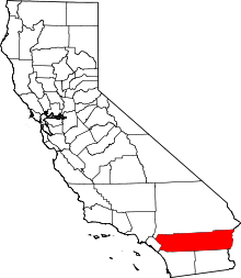
 Location in Riverside County and the state of California | |
| Coordinates: 33°54′33″N 116°45′59″W / 33.90917°N 116.76639°WCoordinates: 33°54′33″N 116°45′59″W / 33.90917°N 116.76639°W | |
| Country |
|
| State |
|
| County | Riverside |
| Area[1] | |
| • Total | 4.893 sq mi (12.674 km2) |
| • Land | 4.868 sq mi (12.608 km2) |
| • Water | 0.025 sq mi (0.066 km2) 0.52% |
| Elevation[2] | 1,834 ft (559 m) |
| Population (2010) | |
| • Total | 2,535 |
| • Density | 520/sq mi (200/km2) |
| Time zone | PST (UTC-8) |
| • Summer (DST) | PDT (UTC-7) |
| ZIP codes | 92230, 92282 |
| Area code | 951 |
| FIPS code | 06-09360 |
| GNIS feature IDs | 1652679, 2407936 |
Cabazon is a census-designated place (CDP) in Riverside County, California, United States. The population was 2,535 during the 2010 Census.
History
Cabazon was established in the 1870s after the Southern Pacific Railroad built a railroad station. The station was originally named Jacinto, but was renamed Cabezone after a nearby Indian rancheria. Cabezone was a chief of the Cahuilla Indians so named for his large head. A worker's camp named Hall's Siding which included a hotel and dance hall was established but eventually abandoned after the railroad relocated. In 1884 a new town was laid out by the Scottish owned Cabazon Land and Water Company which established a fruit farm. Some lots were sold, but later repurchased, and the land stayed intact until it was bought by a developer in 1910. The developer established a school and a post office but there were few residents.[3]
Cabazon was incorporated as a city in 1955. In 1972, after years of scandal, political instability, and stalled growth, the citizens of Cabazon voted to disincorporate the city.[4] Interest in re-incorporating the area has been reported in the 2000s.[5]
Geography
Cabazon is located at 33°54′33″N 116°45′59″W / 33.90917°N 116.76639°W (33.909086 -116.766373).[6] According to the United States Census Bureau, the CDP has a total area of 4.9 square miles (13 km2). 4.9 square miles (13 km2) of it is land and 0.025 square miles (0.065 km2) of it is water. The total area is 0.52% water.
Climate
According to the Köppen Climate Classification system, Cabazon has a warm-summer Mediterranean climate, abbreviated "Csa" on climate maps.[7]
| Climate data for Cabazon, California | |||||||||||||
|---|---|---|---|---|---|---|---|---|---|---|---|---|---|
| Month | Jan | Feb | Mar | Apr | May | Jun | Jul | Aug | Sep | Oct | Nov | Dec | Year |
| Record high °F (°C) | 60.7 (15.9) |
68.5 (20.3) |
74.5 (23.6) |
83.7 (28.7) |
90.4 (32.4) |
95.1 (35.1) |
99.4 (37.4) |
98.2 (36.8) |
94.4 (34.7) |
88.9 (31.6) |
75.7 (24.3) |
61.4 (16.3) |
99.4 (37.4) |
| Average high °F (°C) | 54.7 (12.6) |
62.4 (16.9) |
67.9 (19.9) |
75.4 (24.1) |
83.8 (28.8) |
91.2 (32.9) |
95.8 (35.4) |
94.5 (34.7) |
89.4 (31.9) |
80.4 (26.9) |
65.7 (18.7) |
55.2 (12.9) |
76.37 (24.64) |
| Daily mean °F (°C) | 45.3 (7.4) |
51.2 (10.7) |
56.0 (13.3) |
61.3 (16.3) |
68.9 (20.5) |
75.7 (24.3) |
80.4 (26.9) |
79.0 (26.1) |
73.9 (23.3) |
64.6 (18.1) |
52.4 (11.3) |
44.3 (6.8) |
62.75 (17.08) |
| Average low °F (°C) | 35.8 (2.1) |
40.0 (4.4) |
44.0 (6.7) |
47.1 (8.4) |
53.9 (12.2) |
60.2 (15.7) |
65.0 (18.3) |
63.4 (17.4) |
58.3 (14.6) |
48.8 (9.3) |
39.1 (3.9) |
33.4 (0.8) |
49.08 (9.48) |
| Record low °F (°C) | 28.9 (−1.7) |
33.1 (0.6) |
36.6 (2.6) |
41.7 (5.4) |
49.2 (9.6) |
56.0 (13.3) |
60.2 (15.7) |
59.8 (15.4) |
53.6 (12) |
42.9 (6.1) |
34.3 (1.3) |
25.5 (−3.6) |
25.5 (−3.6) |
| Average precipitation inches (mm) | 1.3 (33) |
1.2 (30) |
1.4 (36) |
0.5 (13) |
0.2 (5) |
0.1 (3) |
0 (0) |
0 (0) |
0.2 (5) |
0.3 (8) |
0.6 (15) |
0.7 (18) |
6.5 (166) |
| Average snowfall inches (cm) | 1.1 (2.8) |
0 (0) |
0 (0) |
0 (0) |
0 (0) |
0 (0) |
0 (0) |
0.6 (1.5) |
0.6 (1.5) |
0 (0) |
0 (0) |
0 (0) |
2.3 (5.8) |
| Avg. rainy days | 5 | 5 | 5 | 3 | 1 | 0 | 1 | 1 | 1 | 2 | 3 | 5 | 32 |
| Source: Weatherbase[8] | |||||||||||||
Demographics
2010
The 2010 United States Census[9] reported that Cabazon had a population of 2,535. The population density was 518.0 people per square mile (200.0/km²). The racial makeup of Cabazon was 1,751 (69.1%) White (42.3% Non-Hispanic White),[10] 135 (5.3%) African American, 90 (3.6%) Native American, 38 (1.5%) Asian, 14 (0.6%) Pacific Islander, 358 (14.1%) from other races, and 149 (5.9%) from two or more races. Hispanic or Latino of any race were 1,135 persons (44.8%).
The Census reported that 2,526 people (99.6% of the population) lived in households, 9 (0.4%) lived in non-institutionalized group quarters, and 0 (0%) were institutionalized.
There were 792 households, out of which 350 (44.2%) had children under the age of 18 living in them, 317 (40.0%) were opposite-sex married couples living together, 181 (22.9%) had a female householder with no husband present, 81 (10.2%) had a male householder with no wife present. There were 81 (10.2%) unmarried opposite-sex partnerships, and 8 (1.0%) same-sex married couples or partnerships. 157 households (19.8%) were made up of individuals and 54 (6.8%) had someone living alone who was 65 years of age or older. The average household size was 3.19. There were 579 families (73.1% of all households); the average family size was 3.68.
The population was spread out with 798 people (31.5%) under the age of 18, 275 people (10.8%) aged 18 to 24, 577 people (22.8%) aged 25 to 44, 674 people (26.6%) aged 45 to 64, and 211 people (8.3%) who were 65 years of age or older. The median age was 31.4 years. For every 100 females there were 101.0 males. For every 100 females age 18 and over, there were 94.5 males.
There were 932 housing units at an average density of 190.5 per square mile (73.5/km²), of which 459 (58.0%) were owner-occupied, and 333 (42.0%) were occupied by renters. The homeowner vacancy rate was 2.5%; the rental vacancy rate was 5.6%. 1,382 people (54.5% of the population) lived in owner-occupied housing units and 1,144 people (45.1%) lived in rental housing units.
According to the 2010 United States Census, Cabazon had a median household income of $33,333, with 22.1% of the population living below the federal poverty line.[11]
2000
As of the census[12] of 2000, there were 2,229 people, 721 households, and 511 families residing in the CDP. The population density was 564.3 people per square mile (217.9/km²). There were 846 housing units at an average density of 214.2 per square mile (82.7/km²). The racial makeup of the CDP was 70.9% White, 4.1% Black or African American, 4.2% Native American, 1.2% Asian, 0.2% Pacific Islander, 13.4% from other races, and 6.1% from two or more races.
There were 721 households out of which 37.6% had children under the age of 18 living with them, 44.2% were married couples living together, 20.8% had a female householder with no husband present, and 29.0% were non-families. 22.5% of all households were made up of individuals and 9.0% had someone living alone who was 65 years of age or older. The average household size was 2.9 and the average family size was 3.5.
In the CDP the population was spread out with 30.5% under the age of 18, 10.5% from 18 to 24, 29.7% from 25 to 44, 18.7% from 45 to 64, and 10.5% who were 65 years of age or older. The median age was 34 years. For every 100 females there were 88.6 males. For every 100 females age 18 and over, there were 90.2 males.
The median income for a household in the CDP was $20,598, and the median income for a family was $24,583. Males had a median income of $29,236 versus $19,444 for females. The per capita income for the CDP was $9,068. About 28.9% of families and 32.3% of the population were below the poverty line, including 25.9% of those under age 18 and 33.1% of those age 65 or over.
Major landmarks

Historic roadside attraction
Claude Bell's giant dinosaur sculptures are icons of roadside America: while many have grown up with them along the highway in southern California, others may also remember them from various films and videos, perhaps most famously Pee-wee's Big Adventure.[13] The site features two sculptures: a 150-ton building in the shape of a larger-than-life-sized Apatosaurus (begun in 1964, completed in 1975), and a 100-ton Tyrannosaurus rex structure (built in 1981).[14][15] The dinosaurs, nicknamed "Dinny" and "Mr. Rex" respectively, were originally built to attract customers to Claude Bell's Wheel Inn Cafe.
The dinosaurs were purchased in 2005 from the Bell family for $1.2 million USD by developers.[16]
Outlet shopping center
Cabazon is a stop for outlet shopping; Desert Hills Premium Outlets[17] and Cabazon Outlets[18] each operate outlet malls.[19]
Native American hotel and casino
Cabazon is also the home of the Morongo Band of Mission Indians, as well as their massive Morongo Casino, Resort & Spa, whose 27-story[20] hotel tower dominates the San Gorgonio Pass.[21] It is one of the largest Native American casinos in the United States.[21] A huge water-bottling facility was established by Arrowhead Mountain Springwater (in partnership with the Morongo Band of Mission Indians) on the eastern edge on Cabazon in 2003.[22]
Library
The Cabazon Library is part of the Riverside County Library System, operated under contract by Library Systems and Services, Inc.[23]
Esperanza Fire
In late October 2006, a major arson fire started near Cabazon.[24] During the course of five days, the Esperanza Fire burned over 40,000 acres (160 km2) and resulted in the deaths of five firefighters,[24] in whose memory California State Route 243 was named the Esperanza Firefighters Memorial Highway.[25]
Government
In the California State Legislature, Cabazon is in the 23rd Senate District, represented by Republican Mike Morrell, and in the 42nd Assembly District, represented by Republican Chad Mayes.[26]
In the United States House of Representatives, Cabazon is in California's 36th congressional district, represented by Democrat Raul Ruiz.[27]
References
- ↑ "2010 Census U.S. Gazetteer Files – Places – California". United States Census Bureau.
- ↑ "Cabazon". Geographic Names Information System. United States Geological Survey. Retrieved December 17, 2014.
- ↑ David W. Kean, Wide Places in the California Roads: The encyclopedia of California's small towns and the roads that lead to them (Volume 1 of 4: Southern California Counties), p. 30.
- ↑ David W. Kean, Wide Places in the California Roads: The encyclopedia of California's small towns and the roads that lead to them (Volume 1 of 4: Southern California Counties), p. 31
- ↑ Moore, Steve (2004-06-04). "Some Cabazon residents want city". The Press-Enterprise. Retrieved 2008-04-11.
- ↑ "US Gazetteer files: 2010, 2000, and 1990". United States Census Bureau. 2011-02-12. Retrieved 2011-04-23.
- ↑ [According to the Köppen Climate Classification system, Hesperia has a warm-summer Mediterranean climate, abbreviated "Csa" on climate maps. Climate Summary for Cabazon, California]
- ↑ "Weatherbase.com". Weatherbase. 2013. Retrieved on October 13, 2013.
- ↑ "2010 Census Interactive Population Search: CA - Cabazon CDP". U.S. Census Bureau. Retrieved July 12, 2014.
- ↑ http://factfinder2.census.gov/faces/tableservices/jsf/pages/productview.xhtml?src=CF. Missing or empty
|title=(help) - ↑ http://factfinder2.census.gov/faces/nav/jsf/pages/community_facts.xhtml. Missing or empty
|title=(help) - ↑ "American FactFinder". United States Census Bureau. Retrieved 2008-01-31.
- ↑ Kine, Starlee (2005-10-09). "In the Belly of the Beast". The New York Times Magazine. Retrieved 2008-04-11.
- ↑ The Cabazon Dinosaurs | The Big Waste of Space Photologue
- ↑ Associated Press, Cabazon, California. Eugene Register-Guard, April 12, 1970. "Cement brontosaurus just beginning: Claude Kenneth Bell and his 'monster'." Hosted by Google Newspapers. Retrieved on January 2, 2010.
- ↑ Powers, Ashley (2005-08-27). "Adam, Eve and T. Rex". The Los Angeles Times. Retrieved 2008-04-11.
- ↑ Desert Hills Premium Outlets
- ↑ Cabazon Outlets
- ↑ Wells, Devona (2004-06-19). "Shopping for outlet malls". The Press-Enterprise. Retrieved 2008-04-11.
- ↑ DeCarlo, Paul (2004-09-24). "Tribe shows fire skills". The Press-Enterprise. Retrieved 2008-04-11.
- ↑ 21.0 21.1 Shikes, Jonathan (2005-04-30). "Beyond the buffet". The Press-Enterprise. Retrieved 2008-04-11.
- ↑ "Arrowhead Bottled Water Facility Earns LEED Silver". GreenBiz.com. 2004-07-29. Retrieved 2008-04-11.
- ↑ http://blog.pe.com/the-pass/2013/02/13/cabazon-library-opens-with-wednesday-feb-13-event/
- ↑ 24.0 24.1 De Atley, Richard K (2007-03-20). "Hearing testimony lays trail to wildfire". The Press-Enterprise. Retrieved 2008-04-11.
- ↑ California Highways: SR 243
- ↑ "Statewide Database". UC Regents. Retrieved December 16, 2014.
- ↑ "California's 36th Congressional District - Representatives & District Map". Civic Impulse, LLC.
External links
 |
San Bernardino Mountains | San Bernardino Mountains | Whitewater | |
| Banning | |
San Gorgonio Pass | ||
| ||||
| | ||||
| San Jacinto Mountains | San Jacinto Mountains | Palm Springs |
| ||||||||||||||||||||||||||||||