Cát Bà National Park
| Cát Bà National Park | |
|---|---|
|
IUCN category II (national park) | |
|
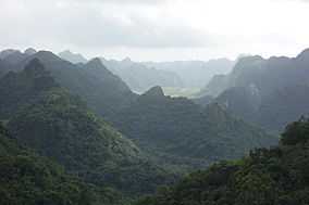
View of the forested limestone landscape of Cát Bà National Park | |
| Location | Vietnam |
| Nearest city | Hai Phong |
| Coordinates | 20°47′50.00″N 107°24′25.50″E / 20.7972222°N 107.4070833°ECoordinates: 20°47′50.00″N 107°24′25.50″E / 20.7972222°N 107.4070833°E |
| Area | 152.00 km2 (58.69 sq mi) |
| Established | 1986 |
Cát Bà National Park is a national park in northern Vietnam. Cát Bà is situated on Cát Bà Island in Hạ Long Bay, is administered by the city of Hai Phong, and belongs to the Cát Hải District of Hai Phong.
The park is located approximately 30 km east of Haiphong, covering about 263 km² and comprising 173 km² land and 90 km² of inshore water.
Cát Bà National Park is a special-use forests in Vietnam, the world's biosphere reserve. Cát Bà National Park is situated in the Cát Hải district, Hai Phong.
History
Cát Bà National Park was established on 31 March 1986 under No.79/CP decision of the Council of Ministers of Vietnam (now the government). Including marine ecosystems, terrestrial forest ecosystem, mangrove ecosystem.
Geography
Cát Bà National Park is located in Hai Phong city center 35 miles to the east. Geographic coordinates:
- 20 ° 43'50 "-20 ° 51'29" north latitude.
- 106 ° 58'20 "-107 ° 10'50" economic winter.
Gia Luan northern border. East of Hạ Long Bay. West and the town of Cát Bà Xuan Dam commune, Chau Tran, Hien Hao.
Area
Total natural area of the park is 16,196.8 hectares. Of which 10,931.7 ha are forests and 5,265.1 ha of sea.
Geography
The roads lead to the national forests of Cát Bà.
Topography
Cát Bà National Park is full of a region of rugged mountains with elevation <500 m, of which most are in the range 50–200 m. Cat Ba island is mainly limestone alternating narrow valleys running along the northeast-southwest.
Geology
Rocks of the island are mainly limestone.
Land
Cát Bà National Park consists of five main soil groups:
- The limestone soil: It is weathered soils or brown reddish-brown limestone and development on sandstone, soil> 50 cm, pH = 6.5 to 7. Distributed under the forest canopy, scattered in the garden.
- The hills feralit brown or brownish yellow on the development of limestone products less acidic or near neutral. In this soil type feralit white or gray yellow brown clay shale development on the hills and sour, thin soil, you're going bad, and rocky, dry soil plates move.
- The valley of dry soil development on limestone or limestone products, concentrated in the valleys, the natural forest cover.
- The Thing Valley land flooding, mainly developed by the accretion process, the rainy season usually submerged, surface soil medium or thin.
- The accretion of land submerged by product deposition in the estuary, the mangrove area development on the Cai Vieng, Phu Long.
Biological resources
Plants
And the single best tree frogs in the pond-area subdivision strict protection
There is a forest type is the type of evergreen tropical rain forest, but due to terrain conditions, land and water regimes, so there is some kind of secondary forests: forests on limestone mountains, mangrove forests along the island, freshwater marsh forest on the mountain. Forests here are also many unique types of forests as ecological associations Kim Affairs (in the region near the peak of Ngu Lam) And the single best (Frog Pond area).
Botanical ingredients are 741 different species, many trees you as son of, while flowers, lim flashed, chestnut flower delivery needle, white type, for the great, the world only in the Himalayas, flooded plants 23 saltwater species, 75 species of seaweed, 199 species of phytoplankton.
Animals
Garden area is available on 282 species including 32 mammals, 78 birds, 20 reptiles and amphibians, 11 species of amphibians. Special Cat Ba Langur species (scientific name: Trachypithecus poliocephalus poliocephalus subspecies), i.e. the golden langur (a number of documents that white-headed langur is wrong, scientific name: Trachypithecus poliocephalus leucocephalus subspecies found only in China) is Narrow endemic species of Cat Ba, currently only 66 individuals, only distributed in the coastal mountains (according to data provided by FPD Cat Ba National Park, 2007). 98 species of zooplankton, 196 species of marine fish, 177 species of coral.[1]
See also
References
| Wikimedia Commons has media related to Cat Ba National Park. |
- ↑ "Introducing Cat Ba National Park". Lonely Planet. Retrieved 25 December 2012.