Bwlchgwyn
| Bwlchgwyn | |
 Pub on the A525 road through Bwlchgwyn |
|
 Bwlchgwyn |
|
| Community | Brymbo |
|---|---|
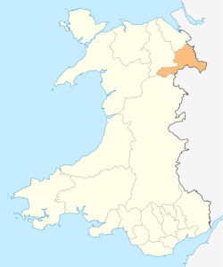
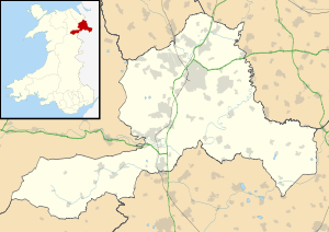
| Principal area | Wrexham |
| Ceremonial county | Clwyd |
| Country | Wales |
| Sovereign state | United Kingdom |
| Post town | WREXHAM |
| Postcode district | LL11 |
| Dialling code | 01978 |
| Police | North Wales |
| Fire | North Wales |
| Ambulance | Welsh |
| EU Parliament | Wales |
| UK Parliament | Clwyd South |
| Welsh Assembly | Clwyd South |
Coordinates: 53°04′20″N 3°05′55″W / 53.072222°N 3.098611°W
Bwlchgwyn is a village in Wrexham county borough, Wales, on the A525 road, 5 miles (8 km) west of the town of Wrexham and 10 miles (16 km) south-east of the town of Ruthin. Bwlchgwyn is part of the community of Brymbo. In the 2011 Census the population of the village was 855.[1]
Etymology
The placename Bwlchgwyn translates into English as "White Pass" which refers to the white limestone cliffs in the area. It has also been suggested that the original name was Bwlchgwynt meaning "Windy Pass".
The name Bwlchgwyn is also said to mean that the pass is white because it is the first and last place in the district where snow settles. Similarly, nearby Gwynfryn means "white hill".
Geography
At a height of 1090 feet (333 m) above sea level, it is one of several places claiming to be the highest village in Wales (although Garn-yr-erw in Torfaen is cited as being the highest by the Ordnance Survey[2]). As the village is so high, there is a good view of the Cheshire Plain, with Jodrell Bank being seen on clear days.
Two rivers have their sources near the village: the River Gwenfro rises on the south side of the village and the Nant-y-Ffrith flows through a wooded valley to the north.
The village is built on Cefn-y-fedw sandstone, a type of Millstone Grit from the Carboniferous period. It contains veins of lead ore and various other minerals.
History
Bwlchgwyn has been inhabited since at least the Bronze Age when a hill fort was built there (now destroyed by quarrying). Until the 19th century the area was common land used for grazing with only a few houses. As with other villages in this area, such as Coedpoeth, Gwynfryn and Minera, the village prospered in the agricultural and industrial revolutions, benefiting from the rich deposit of silica underground. Local quarries and coal mines provided employment, and the village grew. The nearby Minera Limeworks was the largest employer in the area until it closed in the 1970s. Several public houses opened in the area, one of which still remains - The King's Head Inn, seen in the photograph above. Two chapels were built in the village: the Nebo Chapel was first built in 1852 and had a peak congregation of 150. Bwlchgwyn School opened in 1875; the building stood for over 100 years before being replaced by a new school. The Welsh-language author Edward Tegla Davies was a pupil and later a teacher there.
Bwlchgwyn today
Today the village has its own primary school, with secondary schooling in Wrexham. The bus company George Edwards and Son is based in Bwlchgwyn. It formerly operated the village bus service but now only runs coach trips. The main road through the village is the A525 between Newcastle-under-Lyme and Rhyl. This creates a high volume of traffic through the village, although this was calmed by road improvements to a parallel route going around the village. There is a pubil house called King's Head, run by the local community.
There is a well-used community centre which is also home to the village post office, the local toddler group and karate club.
References
- ↑ Office for National Statistics. "Census 2011 Usual resident population". Retrieved 2 July 2013.
- ↑ Ordnance Survey. "MapZone". Retrieved 2007-03-04.
- Gwenda Lewis (2005) I Remember... My Life in Bwlchgwyn 1939-1943.
External links
| ||||||||||||||||||||||||||||||||||||