Buxières-les-Mines
| Buxières-les-Mines | |
|---|---|
|
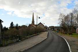
The road into Buxières-les-Mines | |
 Buxières-les-Mines | |
|
Location within Auvergne region  Buxières-les-Mines | |
| Coordinates: 46°28′08″N 2°57′38″E / 46.4689°N 2.9606°ECoordinates: 46°28′08″N 2°57′38″E / 46.4689°N 2.9606°E | |
| Country | France |
| Region | Auvergne |
| Department | Allier |
| Arrondissement | Moulins |
| Canton | Bourbon-l'Archambault |
| Intercommunality | Bocage Bourbonnais |
| Government | |
| • Mayor (2008–2014) | Olivier Françcois |
| Area1 | 46.95 km2 (18.13 sq mi) |
| Population (2008)2 | 1,078 |
| • Density | 23/km2 (59/sq mi) |
| INSEE/Postal code | 03046 / 03440 |
| Elevation |
239–391 m (784–1,283 ft) (avg. 290 m or 950 ft) |
|
1 French Land Register data, which excludes lakes, ponds, glaciers > 1 km² (0.386 sq mi or 247 acres) and river estuaries. 2 Population without double counting: residents of multiple communes (e.g., students and military personnel) only counted once. | |
Buxières-les-Mines is a commune in the Allier department in central France.
Population
| Historical population | ||
|---|---|---|
| Year | Pop. | ±% |
| 1962 | 1,949 | — |
| 1968 | 1,661 | −14.8% |
| 1975 | 1,379 | −17.0% |
| 1982 | 1,380 | +0.1% |
| 1990 | 1,241 | −10.1% |
| 1999 | 1,180 | −4.9% |
| 2008 | 1,078 | −8.6% |
Transport
Buxières-les-Mines was served by railway. The railway station was Gare de Chavenon in the nearby city of Chavenon. It was used for the transport of coal.
Personalities
- Louis Ganne, composer and conductor, was born in Buxières-les-Mines.
See also
References
| Wikimedia Commons has media related to Buxières-les-Mines. |