Butzbach
| Butzbach | ||
|---|---|---|
|
Aerial view | ||
| ||
 Butzbach | ||
Location of Butzbach within Wetteraukreis district 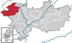
 | ||
| Coordinates: 50°26′12″N 8°39′44″E / 50.43667°N 8.66222°ECoordinates: 50°26′12″N 8°39′44″E / 50.43667°N 8.66222°E | ||
| Country | Germany | |
| State | Hesse | |
| Admin. region | Darmstadt | |
| District | Wetteraukreis | |
| Government | ||
| • Mayor | Michael Merle (SPD) | |
| Area | ||
| • Total | 106.60 km2 (41.16 sq mi) | |
| Population (2013-12-31)[1] | ||
| • Total | 24,384 | |
| • Density | 230/km2 (590/sq mi) | |
| Time zone | CET/CEST (UTC+1/+2) | |
| Postal codes | 35510 | |
| Dialling codes | 06033 | |
| Vehicle registration | FB | |
| Website | www.stadt-butzbach.de | |
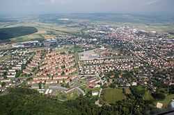

Butzbach (German pronunciation: [ˈbʊtsbax]) is a town in the Wetteraukreis district in Hessen, Germany. It is located approximately 16 km south of Gießen and 35 km north of Frankfurt am Main.
In 2007, the town hosted the 47th Hessentag state festival from 1 to 10 June.
The "Landgrafenschloss" ("landgraves' castle"), used by the United States Army until 1990, is now utilized by the city council. The so-called "Roman Way Housing" of the United States Army with more than 1000 apartments was abandoned in October 2007 and is now empty. The town's market place is enclosed by timber framing. The "Schrenzer" hill (or Heidelbeerberg, 385 m) overlooks the town and the country north of Frankfurt, called Wetterau. Another much higher mountain nearby is the Hausberg which features a look-out tower.
Twin towns — sister cities
-
 Collecchio, Italy – since 2012
 -
 Eilenburg, Saxony, Germany – since 1990
 -
 Saint-Cyr-l'École, France – since 2008
 -
 Teplá, Czech Republic
Notable people
- Ron Gardenhire, Major League Baseball manager for the Minnesota Twins
- Lieutenant Darwin Nichols, an African American pilot, was incarcerated in a Gestapo prison in Butzbach during World War II.[2]
References
- ↑ "Die Bevölkerung der hessischen Gemeinden". Hessisches Statistisches Landesamt (in German). September 2014.
- ↑ "Blacks During the Holocaust". Holocaust Encyclopedia. US Holocaust Memorial Museum. Retrieved 26 September 2012.
External links
| Wikimedia Commons has media related to Butzbach. |
- Official website (German)
- Town museum website (German)
- English description (English)
| ||||||||