Butler Flats Light
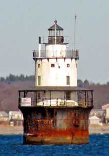 Lighthouse in 2007 | |
 | |
| Location | New Bedford Channel, Acushnet River, New Bedford, Massachusetts |
|---|---|
| Coordinates | 41°36′13.5″N 70°53′40″W / 41.603750°N 70.89444°WCoordinates: 41°36′13.5″N 70°53′40″W / 41.603750°N 70.89444°W |
| Year first constructed | 1898 |
| Year first lit | 1898 |
| Automated | 1978 |
| Foundation | Cast iron/Concrete Caisson |
| Construction | Brick |
| Tower shape | Conical on cylindrical base |
| Markings / pattern | White tower with black base and lantern |
| Focal height | 53 feet (16 m) |
| Original lens | Fifth order Fresnel lens |
| Characteristic | Flashing white 4s |
| Admiralty number | J0498 |
| ARLHS number | USA-099 |
| USCG number | |
|
Butler Flats Light Station | |
| Area | less than one acre |
| Architect | F. Hopkinson Smith |
| Governing body | U.S. Coast Guard |
| MPS | Lighthouses of Massachusetts TR |
| NRHP Reference # |
87001530 [4] |
| Added to NRHP | June 15, 1987 |
Butler Flats Light, New Bedford, Massachusetts is a sparkplug lighthouse located in the New Bedford outer harbor, at the mouth of the Acushnet River. It is currently operated by the City of New Bedford. The lighthouse is not open to the public, but is easily visible from the shore along East Rodney French Boulevard in New Bedford as well as other points along the city's waterfront.
The light was added to the National Register of Historic Places as Butler Flats Light Station on June 15, 1987.[4]
See also
References
- ↑ "Historic Light Station Information and Photography: Massachusetts". United States Coast Guard Historian's Office.
- ↑ Light List, Volume I, Atlantic Coast, St. Croix River, Maine to Shrewsbury River, New Jersey (PDF). Light List. United States Coast Guard. 2009. p. 151.
- ↑ Rowlett, Russ (2009-12-15). "Lighthouses of the United States: Southeast Massachusetts". The Lighthouse Directory. University of North Carolina at Chapel Hill.
- ↑ 4.0 4.1 "National Register Information System". National Register of Historic Places. National Park Service. 2009-03-13.
| |||||||||||||||||||||||||||||||||||||||||||||||||||||||
