Burnside, Victoria
| Burnside Melbourne, Victoria | |||||||||||||
|---|---|---|---|---|---|---|---|---|---|---|---|---|---|
|
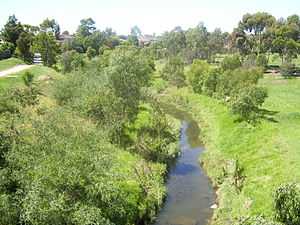
Kororoit Creek | |||||||||||||
 Burnside | |||||||||||||
| Coordinates | 37°45′11″S 144°45′14″E / 37.753°S 144.754°ECoordinates: 37°45′11″S 144°45′14″E / 37.753°S 144.754°E | ||||||||||||
| Population | 4,385 (2011 census)[1] | ||||||||||||
| • Density | 997/km2 (2,581/sq mi) | ||||||||||||
| Established | 1990s | ||||||||||||
| Postcode(s) | 3023 | ||||||||||||
| Area | 4.4 km2 (1.7 sq mi) | ||||||||||||
| Location | 22 km (14 mi) from Melbourne | ||||||||||||
| LGA(s) | City of Melton | ||||||||||||
| State electorate(s) | Kororoit | ||||||||||||
| Federal Division(s) | Gorton | ||||||||||||
| |||||||||||||
Burnside is a suburb of Melbourne, Victoria, Australia, 22 km west of Melbourne's Central Business District. Its local government area is the City of Melton. At the 2011 Census, Burnside had a population of 4,385.
Attractions
- Burnside Shopping Centre
- Kororoit Creek
Burnside is located beside the upper end of the Kororoit Creek, which still has populations of native reptiles, including Tiger snake, Eastern Blue-tongued Lizard, Common snakeneck turtle and Eastern brown snake.
Kororoit Creek is also home to the Eastern Banjo Frog, Common Eastern Froglet and even the endangered Growling Grass Frog and Striped Legless Lizard.
See also
References
- ↑ Australian Bureau of Statistics (31 October 2012). "Burnside (State Suburb)". 2011 Census QuickStats. Retrieved 29 June 2012.
| ||||||