Burnham-on-Sea railway station
| Burnham-on-Sea | |
|---|---|
|
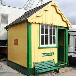
The old signal box, now restored at Washford | |
| Location | |
| Place | Burnham-on-Sea |
| Area | Sedgemoor |
| Grid reference | ST305488 |
| Operations | |
| Pre-grouping | Somerset Central Railway |
| Post-grouping |
SR and LMS Southern Region of British Railways |
| Platforms | 1 |
| History | |
| 3 May 1858 | Opened (Burnham) |
| 12 July 1920 | Renamed (Burnham-on-Sea) |
| 29 October 1951 | Closed to passenger traffic |
| 8 September 1962 | Closed to excursion traffic |
| 20 May 1963 | Closed to goods traffic |
| Disused railway stations in the United Kingdom | |
|
Closed railway stations in Britain A B C D–F G H–J K–L M–O P–R S T–V W–Z | |
| UK Railways portal | |
Burnham-on-Sea railway station at Burnham-on-Sea was the terminus of the Burnham branch of the Somerset and Dorset Joint Railway. Opened as Burnham by the Somerset Central Railway on 3 May 1858, it was renamed in 1920.
History
The station, situated behind Abingdon Street, was a terminus although a through platform allowed services to travel on to a 900 ft pier on the river. For a few years the railway operated steamers across the Bristol Channel to Wales.[1] Railway operations onto the pier ceased in 1888 although the pier continued in use for vessels until the 1950s. Perhaps the strangest use of the railway along the pier was by lifeboat, which was pushed on rails from the old lifeboat station (behind the current Morrisons store) and onto the "main line", across the esplanade, and down the pier where the lifeboat could be launched if the tide was right[2]
Burnham-on-Sea closed when regular passenger services were curtailed at Highbridge on the 28 October 1951. Excursion traffic continued until 1962, and the goods depot remained open until 1963.
The nearest station to Burnham is now the former join-GWR junction station known as Highbridge and Burnham.
_rai_station_1941038_ff3e9887.jpg)
| Preceding station | Disused railways | Following station | ||
|---|---|---|---|---|
| Highbridge & Burnham Line closed station open |
Somerset & Dorset Joint Railway LSWR and Midland Railways |
Terminus | ||
The site today
After station's closure, the platform and goods shed were demolished. An adjacent pub on the High Street was resultantly renamed the Somerset & Dorset. The new RNLI station and yard occupy land to the south and east of the former main station building, adjacent to the site of the former excursion platform. The first ever specifically-designed Somerfield supermarket was built to the seaward-west side, which is now a Morrisons. The former trackbed eastwards was developed into Marine Drive, a road which has helped ease traffic flow into the town.[3]
Further reading
- R.V.J.Butt, (1995). The Directory of Railway Stations. Patrick Stephens Ltd. ISBN 1-85260-508-1