Burgas Peninsula

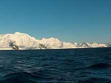
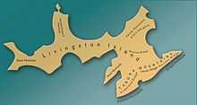
Burgas Peninsula (Poluostrov Burgas \po-lu-'os-trov bur-'gas\) is a predominantly ice-covered peninsula forming the east extremity of Livingston Island in the South Shetland Islands, Antarctica extending 10 km in the east-northeast direction towards Renier Point and 4.7 km wide. It is bounded by Bruix Cove, Moon Bay and Mugla Passage to the north, and Bransfield Strait to the south-southeast. The peninsula's interior is occupied by the Delchev Ridge of Tangra Mountains.
The Burgas Peninsula is named after the Bulgarian city of Burgas.
Location
The peninsula is centred at 62°37′40″S 59°54′00″W / 62.62778°S 59.90000°WCoordinates: 62°37′40″S 59°54′00″W / 62.62778°S 59.90000°W. British mapping in 1822 and 1968, Chilean in 1971, Argentine in 1980, Spanish mapping in 1991, and Bulgarian topographic survey Tangra 2004/05 and mapping in 2005 and 2009.
See also
Maps

- L.L. Ivanov et al. Antarctica: Livingston Island and Greenwich Island, South Shetland Islands. Scale 1:100000 topographic map. Sofia: Antarctic Place-names Commission of Bulgaria, 2005.
- L.L. Ivanov. Antarctica: Livingston Island and Greenwich, Robert, Snow and Smith Islands. Scale 1:120000 topographic map. Troyan: Manfred Wörner Foundation, 2010. ISBN 978-954-92032-9-5 (First edition 2009. ISBN 978-954-92032-6-4)
References
This article includes information from the Antarctic Place-names Commission of Bulgaria which is used with permission.