Burden, Kansas
| Burden, Kansas | |
|---|---|
| City | |
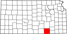
 Location of Burden, Kansas | |
 | |
| Coordinates: 37°18′51″N 96°45′19″W / 37.31417°N 96.75528°WCoordinates: 37°18′51″N 96°45′19″W / 37.31417°N 96.75528°W | |
| Country | United States |
| State | Kansas |
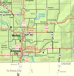
| County | Cowley |
| Area[1] | |
| • Total | 0.54 sq mi (1.40 km2) |
| • Land | 0.53 sq mi (1.37 km2) |
| • Water | 0.01 sq mi (0.03 km2) |
| Elevation | 1,381 ft (421 m) |
| Population (2010)[2] | |
| • Total | 535 |
| • Estimate (2012[3]) | 536 |
| • Density | 1,009.4/sq mi (389.7/km2) |
| Time zone | Central (CST) (UTC-6) |
| • Summer (DST) | CDT (UTC-5) |
| ZIP code | 67019 |
| Area code(s) | 620 |
| FIPS code | 20-09250[4] |
| GNIS feature ID | 0469910[5] |
Burden is a city in Cowley County, Kansas, United States. As of the 2010 census, the city population was 535.[6]
History
Burden was founded in 1879.[7] It was named for one of its founders, Robert F. Burden.[7][8]
The first post office in Burden (called Burdenville until 1884) was established in 1879.[9]
Burden was a station and shipping point on the Atchison, Topeka and Santa Fe Railway.[10]
Geography
Burden is located at 37°18′51″N 96°45′19″W / 37.31417°N 96.75528°W (37.314128, -96.755377).[11] According to the United States Census Bureau, the city has a total area of 0.54 square miles (1.40 km2), of which, 0.53 square miles (1.37 km2) is land and 0.01 square miles (0.03 km2) is water.[1]
Demographics
| Historical population | |||
|---|---|---|---|
| Census | Pop. | %± | |
| 1990 | 518 | — | |
| 2000 | 564 | 8.9% | |
| 2010 | 535 | −5.1% | |
| U.S. Decennial Census | |||
2010 census
As of the census[2] of 2010, there were 535 people, 195 households, and 145 families residing in the city. The population density was 1,009.4 inhabitants per square mile (389.7/km2). There were 234 housing units at an average density of 441.5 per square mile (170.5/km2). The racial makeup of the city was 97.2% White, 1.7% Native American, and 1.1% from two or more races. Hispanic or Latino of any race were 3.7% of the population.
There were 195 households of which 40.0% had children under the age of 18 living with them, 53.3% were married couples living together, 12.8% had a female householder with no husband present, 8.2% had a male householder with no wife present, and 25.6% were non-families. 23.1% of all households were made up of individuals and 12.8% had someone living alone who was 65 years of age or older. The average household size was 2.74 and the average family size was 3.22.
The median age in the city was 33.2 years. 31.4% of residents were under the age of 18; 7.8% were between the ages of 18 and 24; 24% were from 25 to 44; 21% were from 45 to 64; and 15.5% were 65 years of age or older. The gender makeup of the city was 50.3% male and 49.7% female.
2000 census
As of the census[4] of 2000, there were 564 people, 210 households, and 158 families residing in the city. The population density was 1,072.0 people per square mile (410.9/km²). There were 236 housing units at an average density of 448.6 per square mile (171.9/km²). The racial makeup of the city was 93.26% White, 0.18% African American, 2.48% Native American, 1.42% from other races, and 2.66% from two or more races. Hispanic or Latino of any race were 1.95% of the population.
There were 210 households out of which 37.6% had children under the age of 18 living with them, 56.2% were married couples living together, 11.9% had a female householder with no husband present, and 24.3% were non-families. 21.4% of all households were made up of individuals and 11.4% had someone living alone who was 65 years of age or older. The average household size was 2.69 and the average family size was 3.12.
In the city the population was spread out with 32.6% under the age of 18, 9.2% from 18 to 24, 26.6% from 25 to 44, 16.1% from 45 to 64, and 15.4% who were 65 years of age or older. The median age was 32 years. For every 100 females there were 97.9 males. For every 100 females age 18 and over, there were 95.9 males.
The median income for a household in the city was $26,641, and the median income for a family was $33,833. Males had a median income of $29,821 versus $17,656 for females. The per capita income for the city was $13,549. About 8.1% of families and 12.2% of the population were below the poverty line, including 14.5% of those under age 18 and 14.4% of those age 65 or over.
References
- ↑ 1.0 1.1 "US Gazetteer files 2010". United States Census Bureau. Retrieved 2012-07-06.
- ↑ 2.0 2.1 "American FactFinder". United States Census Bureau. Retrieved 2012-07-06.
- ↑ "Population Estimates". United States Census Bureau. Retrieved 2013-05-29.
- ↑ 4.0 4.1 "American FactFinder". United States Census Bureau. Retrieved 2008-01-31.
- ↑ "US Board on Geographic Names". United States Geological Survey. 2007-10-25. Retrieved 2008-01-31.
- ↑ "2010 City Population and Housing Occupancy Status". U.S. Census Bureau. Retrieved March 6, 2011.
- ↑ 7.0 7.1 Kansas State Historical Society (1916). Biennial Report of the Board of Directors of the Kansas State Historical Society. Kansas State Printing Plant. p. 168.
- ↑ "Profile for Burden, Kansas". ePodunk. Retrieved 7 June 2014.
- ↑ "Kansas Post Offices, 1828-1961 (archived)". Kansas Historical Society. Retrieved 6 June 2014.
- ↑ Blackmar, Frank Wilson (1912). Kansas: A Cyclopedia of State History, Embracing Events, Institutions, Industries, Counties, Cities, Towns, Prominent Persons, Etc. Standard Publishing Company. p. 252.
- ↑ "US Gazetteer files: 2010, 2000, and 1990". United States Census Bureau. 2011-02-12. Retrieved 2011-04-23.
Further reading
- County
- History of Cowley County Kansas; D.A. Millington / E.P. Greer; Winfield Courier; 162 pages; 1901. (Download 16MB PDF eBook)
- Kansas
- History of the State of Kansas; William G. Cutler; A.T. Andreas Publisher; 1883. (Online HTML eBook)
- Kansas : A Cyclopedia of State History, Embracing Events, Institutions, Industries, Counties, Cities, Towns, Prominent Persons, Etc; 3 Volumes; Frank W. Blackmar; Standard Publishing Co; 944 / 955 / 824 pages; 1912. (Volume1 - Download 54MB PDF eBook), (Volume2 - Download 53MB PDF eBook), (Volume3 - Download 33MB PDF eBook)
External links
| Wikimedia Commons has media related to Burden, Kansas. |
- City
- Schools
- USD 462, local school district
- Historical
- Forgotten Item Market on YouTube, from Hatteberg's People on KAKE TV news
- Maps
- Burden City Map, KDOT
| |||||||||||||||||||||||||