Burdekin Dam
| Burdekin Dam | |
|---|---|
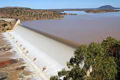 Burdekin Dam in 2009 | |
| Location | 165 km south of Townsville |
| Coordinates | 20°38′37″S 147°08′17″E / 20.6435°S 147.138°ECoordinates: 20°38′37″S 147°08′17″E / 20.6435°S 147.138°E |
| Type | reservoir |
| Primary inflows | Burdekin River, Belyando River |
| Primary outflows | Burdekin River |
| Basin countries | Australia |
| Surface area | 220 km² |
| Max. depth | 40 m |
| Water volume | 1,860,000 ML [1] |
| Surface elevation | 154 m |
| References | [1] |
Burdekin Dam (or Burdekin Falls Dam) is located on the Burdekin River in Queensland, Australia south west of Ayr, and Home Hill. The body of water held by the dam is also known as Lake Dalrymple. Burdekin Dam is managed by SunWater. The dam provides drinking water for twin cities of Thuringowa and Townsville and a large irrigation scheme. Water from the dam is also used to replenish downstream aquifers.[2]
The dam wall is 876 metres long and has a 504 metre spillway, and a drop of 37 metres. It holds 1,860,000 megalitres at full capacity. The design allows for future storage capacity increases and potential for hydro-electricity generation.[2] Plans are in place to increase the safety of this dam in an extreme rainfall event by increasing the spillway capacity. This project is scheduled for completion over the next 5 to 20 years.[3]
The catchment area for the dam extends north to the Seaview Range west of Ingham, south to the Drummond Range near Alpha through the Suttor and Belyando Rivers, southeast to the coastal ranges west of Mackay, and west beyond Charters Towers to the Lolworth, Montgomery and Stopem Blockem Ranges through the Clarke River.
History
Construction of the dam began in 1984. It was completed by Leighton Holdings in 1987 and is the largest dam in the state, with a capacity four times that of Sydney Harbour.[4] Burdekin Dam filled after the wet season in 1988.[2]
Irrigation
The Burdekin River Irrigation Area was granted approval in 1980. It is Queensland's largest land and water conservation scheme.[2] In 2007, the scheme was supplying 103,000 ha of land located about 200 km inland from Townsville with water to grow a range of crops including sugar cane, cotton and rice.[2]
Proposed Hydro
Stanwell Corporation has begun a feasibility study into a proposed 37 MW hydro power station below the Burdekin Dam wall. It is proposed it would be capable of producing 125,000 MWh annually, enough to power more than 9,500 homes each year.[5]
Boating
There are no boating restrictions, with a single boat ramp located near the dam wall. Water in the dam is often muddied with unsettled sediment long after the rains have washed it into the lake. This not only makes angling difficult but also means boating can be hazardous at high speeds due to the presence of submerged rocks.[6]
Fauna and flora
The dam has been stocked with sleepy cod, sooty grunter and barramundi. Numerous other species are present naturally, including forktail catfish, spangled perch, eel-tailed catfish, long tom, golden perch and archer fish.[6] A Stocked Impoundment Permit is required to fish in the dam.[7] Red-claw crayfish and saltwater crocodiles are also found in the dam.[6]
See also
- List of dams and reservoirs in Australia
References
- ↑ 1.0 1.1 Sunwater Current Water Storage Information
- ↑ 2.0 2.1 2.2 2.3 2.4 Pigram, John J. (2007). Australia's Water Resources: From use to management. Collingwood, Victoria: CSIRO Publishing. pp. 50–51. ISBN 978-0-643-09442-0.
- ↑ Current Projects
- ↑ Leighton Holdings History
- ↑ "Burdekin Hydro". Stanwell Corp. Retrieved 4 February 2012.
- ↑ 6.0 6.1 6.2 Harrison, Rod; Ernie James; Chris Sully; Bill Classon; Joy Eckermann (2008). Queensland Dams. Bayswater, Victoria: Australian Fishing Network. pp. 92–93. ISBN 978-1-86513-134-4.
- ↑ Fishing in Queensland dams? You may need a permit.
External links
- Pictures- National Library of Australia
- More historical Photos from the NQ Dry Tropics
- Burdekin Dam Fishing Information & Map
| ||||||||||||||||||||||||||||||||||