Bullgill
| Bullgill | |
 |
|
 Bullgill |
|
| Shire county | Cumbria |
|---|---|
| Region | North West |
| Country | England |
| Sovereign state | United Kingdom |
| Postcode district | CA |
| Police | Cumbria |
| Fire | Cumbria |
| Ambulance | North West |
| EU Parliament | North West England |
Coordinates: 54°44′00″N 3°24′25″W / 54.733301°N 3.406978°W
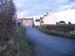
Bullgill is a hamlet in Cumbria, England. It is located to the northeast of Dearham, 4.3 miles (6.9 km) by road northeast of Maryport and 0.5 miles (0.80 km) southeast of Crosby Villa.[1] The River Ellen flows nearby. The Ellen Pit coal mine was sunk in 1859.[2]
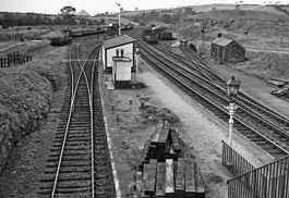
 Bullgill railway station |
A railway station was formerly located at Bulgill connecting it with Carlisle. It closed to passengers on 7 March 1960. Bullgill station was the nearest to Maryport.[3]
See also
References
- ↑ Maps (Map). Google Maps.
- ↑ Millward, Roy; Robinson, Adrian Henry Wardle (1 January 1972). Cumbria. Macmillan. p. 160. Retrieved 10 July 2012.
- ↑ The Leisure hour. s.n. 1903. Retrieved 10 July 2012.