Bukit Mertajam
| Bukit Mertajam 大山脚 | |
|---|---|
| Town | |
|
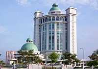
Church of St Anne, Bukit Mertajam | |
| Nickname(s): BM | |
 Bukit Mertajam Location in Peninsular Malaysia | |
 Bukit Mertajam Location in Malaysia | |
| Coordinates: 5°22′0″N 100°28′0″E / 5.36667°N 100.46667°E | |
| Country | Malaysia |
| State | Penang |
| District | Central Seberang Perai |
| Government | |
| • Tuan Yang DiPertua MPSP | Maimunah binti Mohd. Sharif |
| • Member of Parliament | Steven Sim Chee Keong |
| Population (2010[1]) | |
| • Total | 227,972 |
| • Density | 590/km2 (1,500/sq mi) |
| Time zone | MST (UTC+8) |
| • Summer (DST) | Not observed (UTC) |
| Postal code | 14000 |
| International dialling code prefix | +6045 (landline only) |
| Website | http://www.mpsp.gov.my |

Bukit Mertajam often known as B.M. is a town in Central Seberang Perai, Penang, Malaysia.
Etymology
The town of Bukit Mertajam is named after the nearby hill with the highest peak at 547m above sea level. The hill is named after the Mertajam tree (Lepisanthes rubiginosa). It is a tree with white flowers that can grow up to 5-12m tall. [2]
Geography
It is located in Central Seberang Perai, in the state of Penang, with Butterworth to the northwest, Penanti to the north, Simpang Ampat to the south and Kulim to the east, and Perai to the west. The town is located about 9 km to the east of the coastline and about 336 km north of Kuala Lumpur.[3]
History
As a major town in Central Seberang Perai, Bukit Mertajam serves as one of the many economic hubs in the northern region.
Although so far there is no complete written record on the early settlement of Bukit Mertajam, archeologists had recently discovered much evidence on the antiquity of the town.
According to archeological findings, there had been early settlement of Bukit Mertajam some 1500 years ago in the 5th century based on the discovery of the Cherok Tokun Relics, which is a stone tablet carved with ancient Sanskrit writings, which is now displayed in the church grounds of the St. Anne’s Church along Kulim Road. During the Kedah kingdom in the 3rd century with heavy influence of Hinduism, paddy was largely cultivated in Bukit Mertajam.
The town’s history can be traced back to 1822 when the immigrants from Huizhou, Guangdong, China began to settle in Penang, involving in farming. Agriculture was once a major industry in Penang. When Penang had become a centre for spice trade in the East Indies to supply the European market, the Huizhou people started cultivation of spice in British colonial settlements in Province Wellesley. Before East India Company gained control of Province Wellesley, the Chinese had already begun their sugarcane plantation in Batu Kawan. In 1800, seeing the high demand of herbs and spices in Europe, the British had encouraged the residents of Bukit Mertajam to grow various spices such as pepper, cloves, cinnamon and nutmeg. Besides agriculture, the residents of Bukit Mertajam begin to engage in alternative income such as quarrying. Bukit Mertajam was the largest producer of granite in the Northern region of Peninsula Malaysia. Granite was used as a construction material for the Penang Prison in Penang island.
The region surrounding Bukit Mertajam during the spice trade era in the 19th century is only accessible by boat and junk. Sungai Juru and Sungai Rambai was the main transportation waterway in the town, with Sungai Rambai and Padang Lalang regions as the main pier that served the town. There was no land transportation that connects the town.
Based on the early Chinese settlers of Bukit Mertajam, the urban planning of the old section of the town was established in 1886 by the Hock Teik Cheng Sin Temple Committee, with the Pek Kong Temple as a town core while the shops, markets and bazaars radiating around the temple. The Chinese community in Bukit Mertajam is mostly from the Teochew clan. They hail mostly from Huizhou, Guangdong, China and speaks the Teochew dialect. The Teochews once made up nearly half of the total population in Seberang Perai.
In 1899, rubber plantation has replaced the sugarcane plantation. During that time, the railway system that connects Prai, Nibong Tebal and Bukit Mertajam has been completed. The railway track which connects Kuala Lumpur and Singapore has been completed in 1909, making railway as the main transportation system. In 1914, rubber was the main production in Bukit Mertajam. With the rapid development and improvement of the transportation system, the population of the town increased dramatically, with the first Malay school opened in Cherok Tok Kun in 1900. The first Chinese vernacular school, Jit Sin School, was opened in 3 March 1918, which was established by the Hock Teik Cheng Sin Temple committee along Jalan Pasar. Bukit Mertajam High School was first opened in 1927, the Convent school was founded in 1931, while Kim Sen School was established in 1939.
Development had been slow before the Second World War. Before the British retreat in 1941 the railway station in Bukit Mertajam had been blown up. The railway station was constructed again in 1942 by the Japanese and used Bukit Mertajam High School as a military base. At that time, Bukit Mertajam High School was forced to close down.
After the Second World War had ended in 1945, Bukit Mertajam had been a thriving town with bustling of business activities and trade. There was a rapid urbanization of the town in 1957. The new hospital along Kulim Road was built in 1960; the new post office was built in 1968, while the new train station was built in 1983. Today, Bukit Mertajam is one of the trading and economic hubs in the northern region in Peninsular Malaysia.
Basic Infrastructure
Bukit Mertajam is administered by the Seberang Perai Municipal Council (Majlis Perbandaran Seberang Perai or MPSP in Malay). MPSP is one of the few municipal councils in Malaysia which administers more than one district. MPSP administers all three districts of the mainland Penang (also known as Province Wellesley). The districts are North, Central and South Seberang Perai.
Bukit Mertajam is a fast-growing town in the Central Seberang Perai district. Due to outward expansion, Bukit Mertajam is increasingly conjoined with other subdivisions, forming an increasingly urbanised area.
There is a government general hospital in the old town of Bukit Mertajam, known as Bukit Mertajam Hospital. Near the hospital, there is also a old KTM railway station which has now moved to Bandar Perda.
Jit Sin High School is one of the top performing schools in the country. Bukit Mertajam High School was established 18 January 1927 and is one of the oldest schools in Malaysia. BM High School is the alma mater of figures like the fifth Prime Minister Tun Abdullah Ahmad Badawi and former Deputy Prime Minister Dato' Seri Anwar bin Ibrahim.
Shopping
- AEON Mall Bukit Mertajam
- Summit Bukit Mertajam Plaza
- Tesco Bukit Mertajam
- Perda City Mall
- Econ Save & Parkson at Bandar Perda area
Healthcare
- Hospital Bukit Mertajam
- KPJ Penang Specialist Hospital
Places of Attraction
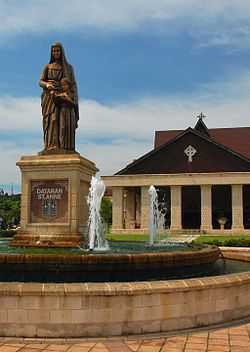
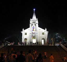
- St. Anne's Church
The historical St. Anne's Church is situated in Bukit Mertajam. The original chapel was built in 1846 by the French priest, Father Adolphe Couellan. The chapel was dedicated to Saint Anne, who is a very popular patron saint amongst the French.
- Bukit Mertajam Recreational Forest
A popular recreational park among locals and outsiders alike, the Bukit Mertajam Recreational Forest in Cherok Tok Kun, Bukit Mertajam is a tropical rain forest reserve sprawls over 37 hectars of hilly terrain including the Bukit Mertajam hill. The forest contains indigenous rain forest trees that could be over a hundred years old such as the Meranti Seraya (Shorea curtisii) and Meranti Rambai Daun (Shorea acuminate). For the adventurous hikers, there are numerous jungle trail branching out towards the peak and also accessible by jeep and cycling. Other activities include picnicking, swimming by the waterfall and camping.[4]
- Mengkuang Titi
A small village of Mengkuang Titi provides homestay programmes for foreign tourists which is the opportunity to live with the local Malay family while experiencing Malay culture and the laid-back lifestyle of rural living. Among the activities during the programme were fruit picking in the orchard, visiting a handicraft centre, Mengkuang-mat-weaving demonstration, a trip cottage industry factories(Malaysian Muffins),bedak sejuk (traditional beauty powder made from rice flour) and soy bean products, visiting the Mengkuang Dam vicinity and the Air Itam Dalam mangrove reserve, a cultural performance, a stroll through a rubber plantation and an oil palm plantation.
- Mengkuang Dam
Mengkuang Dam is a man-made lake that has natural and scenic landscapes. It is home to various forms of wildlife including insects and reptiles. The park in the reservoir area serves as a popular recreation spot for local residents of Bukit Mertajam. Jogging, trekking and picnicking are the common activities in the recreational area. It forms the largest water catchment area in Penang.[5]
- Auto City
Highway Auto City Juru which is located near the North-South Expressway is a popular hot spot among locals and tourists as an automobile, shopping, food and entertainment centre. Many outdoor events and celebrations like roadshows, concerts, carnivals, exhibitions, motor sports and cultural festivals are being held there.[6]
- Pek Kong Cheng
Pek Kong Cheng, located along Pasar Road in Bukit Mertajam town centre, is a food haven with hawker stalls at the courtyard of the 120-year-old Pek Kong Temple. One of the top delicacies include white Wonton noodles, Koay Teow Soup, Loh Shee Fun and Hokkien noodles. There will be stage Chinese opera performances occasionally.[7] The Hungry Ghost Festival is being held annually here on the seventh month of the Chinese lunar calendar and the town boasts the largest and tallest paper effigy of the King of Hades in the country, in which 10,000 devotees turn up to offer prayers every year.[8]
- Cherok Tokun Relics
Also known as Batu Bersurat Cherok Tokun, it is the only archaeological site in Penang which contains ancient Pali inscriptions on a granite rock. It is located at the foot of Bukit Mertajam, within the compounds of St. Anne's Church. [9]
Festivals
- St. Anne's Novena and Feast
St. Anne's Novena and Feast is held annually in the end of July at the St. Anne's Church, Bukit Mertajam. It attracts nearly 100,000 pilgrims nation-wide and outside the country and one of the largest Catholic celebrations in the country. Among the highlights are the candlelight procession and a holy parade through the streets bearing the statue of St. Anne.
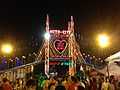
- Hungry Ghost Festival
Hungry Ghost Festival is held at the Pek Kong Temple along Pasar Road during the seventh month of the Chinese lunar calendar which boasts a 10m-tall effigy of the King of Hades. Among the highlights of the month-long festival are stage concerts known as 'kotai' and recital performances to entertain the spirits. At the 17th day of the celebration, about 10,000 pilgrims gathered at night to witness the send-off of the King of Hades which is the burning the paper effigy of the deity, which symbolises the departure of the deity back to the underworld.
Transport
Roads
- North-South Expressway connects the town to major cities in Malaysia such as Kuala Lumpur and Alor Setar via the Juru and Prai interchange.
- Butterworth-Kulim Expressway connects the town via the Permatang Nibong interchange.
- Penang Bridge connects the town to George Town, Penang in Penang island.
Public transport
- The Bukit Mertajam railway station serves the residents of the town which connects the north and south of the Malay Peninsula.
- Rapid Penang Sdn. Bhd. provides bus services starting from July 31, 2007.
Image Gallery
-
Lavishly decorated entrance to the Shop In d'Park in Auto City Juru
-
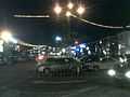
Auto City in the evening during weekends
-
St. Anne's Sanctuary
-
Old Shrine of St. Anne's Church
-
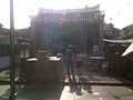
Front courtyard of Pek Kong Temple at Jalan Pasar
-
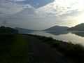
Jogging track along Mengkuang Dam at dawn
-
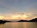
Mengkuang Dam at dusk
-
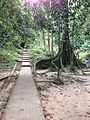
An uphill track leading to a secondary jungle at the Bukit Mertajam Recreational Forest in Cherok Tok Kun.
See also
- Northern Corridor Economic Region
References
- ↑ "Malaysia: largest cities and towns and statistics of their population". World Gazetteer. Retrieved 2010-10-31.
- ↑ Bukit Mertajam
- ↑ "The North South Expressway".
- ↑ "Bukit Mertajam Recreational Forest".
- ↑ "Mengkuang Dam".
- ↑ "Auto City".
- ↑ http://thestar.com.my/metro/story.asp?file=/2009/6/7/sundaymetro/4051290&sec=sundaymetro
- ↑ http://www.pulaupinang.com/tag/bukit-mertajam/
- ↑ "Cherok Tokun Relics".
External links
 |
Penanti | | ||
| Perai | |
| ||
| ||||
| | ||||
| Simpang Ampat |