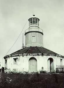
Bugui Point Lighthouse
Bugui Point Lighthouse is a historic lighthouse located on Bugui Point in the town of Aroroy, in the northern tip of Masbate Island, province of Masbate, in the Philippines. It lights the entrance to the channel between Burias Island and Masbate Island and the channel between Burias and Ticao Islands leading to San Bernardino Strait.[2]
Work on the light was started in October 1893, but worked was stopped on November 1896 with the onset of the Philippine Revolution. Lighthouse construction was continued by the Americans in 1902 and the light was finally lit on December 1, 1902.
See also
External links
References
- ↑ "Pub.112 List of Lights", p.190. National Geospatial-Intelligence Agency, 2009.
- ↑ Bureau of Insular Affairs, U.S. War Department, "A Pronouncing Gazetteer and Geographical Dictionary of the Philippine Island", p.110. Washington Government Printing Office, 1902.
.svg.png)

