Buck Creek Township, Hancock County, Indiana
| Buck Creek Township | |
|---|---|
| Township | |
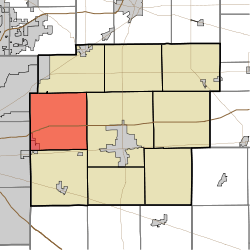 Location in Hancock County | |
| Coordinates: 39°49′38″N 85°53′54″W / 39.82722°N 85.89833°WCoordinates: 39°49′38″N 85°53′54″W / 39.82722°N 85.89833°W | |
| Country | United States |
| State | Indiana |
| County | Hancock |
| Government | |
| • Type | Indiana township |
| Area | |
| • Total | 36.02 sq mi (93.3 km2) |
| • Land | 35.93 sq mi (93.1 km2) |
| • Water | 0.09 sq mi (0.2 km2) 0.25% |
| Elevation | 846 ft (258 m) |
| Population (2010) | |
| • Total | 8,430 |
| • Density | 234.6/sq mi (90.6/km2) |
| GNIS feature ID | 0453145 |
Buck Creek Township is one of nine townships in Hancock County, Indiana, United States. As of the 2010 census, its population was 8,430 and it contained 3,158 housing units.[1]
History
Buck Creek Township was established in 1831.[2] It was named from Buck Creek, its largest waterway.[3]
Geography
According to the 2010 census, the township has a total area of 36.02 square miles (93.3 km2), of which 35.93 square miles (93.1 km2) (or 99.75%) is land and 0.09 square miles (0.23 km2) (or 0.25%) is water.[1] The streams of Amity Branch, Lead Creek and Snider Branch run through this township.
Cities and towns
- Cumberland
- Cumberland (northeast half)
Unincorporated towns
- Mohawk
- Mount Comfort
- Pleasant Acres
(This list is based on USGS data and may include former settlements.)
Adjacent townships
- Vernon Township (north)
- Center Township (east)
- Sugar Creek Township (south)
- Warren Township, Marion County (southwest)
- Lawrence Township, Marion County (northwest)
Cemeteries
The township contains nine cemeteries: Arnett, Burris, Fish, Griffith, Mount Pleasant, Pet, Scotten, Snider and Steele.
Major highways
Airports and landing strips
- Indianapolis Regional Airport
References
- "Buck Creek Township, Hancock County, Indiana". Geographic Names Information System. United States Geological Survey. Retrieved 2009-09-24.
- United States Census Bureau cartographic boundary files
- ↑ 1.0 1.1 "Population, Housing Units, Area, and Density: 2010 - County -- County Subdivision and Place -- 2010 Census Summary File 1". United States Census. Retrieved 2013-05-10.
- ↑ Richman, George J. (1916). History of Hancock County, Indiana: Its People, Industries and Institutions. Wm. Mitchell Printing Company. p. 556.
- ↑ Binford, John H. (1882). History of Hancock County, Indiana: From Its Earliest Settlement by the "pale Face," in 1818, Down to 1882. King & Binford. p. 114.
External links
| |||||||||||||||||||||||||||||