Bryan Station
| Siege of Bryan Station | |||||||
|---|---|---|---|---|---|---|---|
| Part of the American Revolutionary War | |||||||
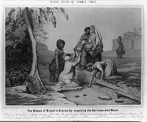
 Illustration of the women of Bryan Station getting water while Native Americans watch, just before besieging the settlement. | |||||||
| |||||||
| Belligerents | |||||||
| Kentucky settlers | American Indians and allies | ||||||
| Commanders and leaders | |||||||
| Capt. Elijah Craig[1] |
William Caldwell, Alexander McKee, | ||||||
| Casualties and losses | |||||||
|
5 killed 2 wounded | |||||||
Bryan Station (also Bryan's Station, and often misspelled Bryant's Station) was an early fortified settlement in Lexington, Kentucky. It was located on present-day Bryan Station Road, about three miles (5 km) north of New Circle Road, on the southern bank of Elkhorn Creek near Briar Hill Road.
The settlement was established circa 1775-76 by brothers Morgan, James, William and Joseph Bryan from North Carolina. The occupants of this parallelogram of some forty log cabins withstood several American Indian attacks. The most important occurred in August 1782 during the American Revolutionary War, when they were besieged by about 300 Shawnee Indians and British Canadians under Captain William Caldwell and Simon Girty. Bryan Station was located a short distance from a spring that the camp used for drinking water.
Since the Shawnee secretly surrounding the fort did not realize that the presence of their large force was known by the defenders, the men allowed the women to exit the fort to retrieve water and other resources. The reason this was done was in order to prevent any change in habit that could signal that the defenders were aware of the presence of the hidden force preparing to besiege them. Historian Ranck asserts that all the important contemporary writers convey this impression: "For the men to go to the spring would be to do exactly as the savages desired and devote the garrison to destruction. If the women went in accordance with their regular early morning custom, the enemy would be confirmed in the delusion that their presence in force was undiscovered,* and would withold their fire to insure the complete success of their plans. The suggestion was full of hope, but all the same the savages were known to be mere creatures of impulse, hard to control and regardless of sex."[2] The Indians had no compunction attacking women, as they had done at nearby Ruddell's and Martin's Stations where even children were slaughtered two years earlier, and so the bravery of the women of Bryan Station is all the greater.
At the time of the siege the militia did not realize just how many Indians were waiting for them outside of the fort or that these Indians had some support from the British. This attack was a surprise attack and the militia in the fort were unprepared for this attack. The attackers lifted the siege after Indian scouts reported that a force of Kentucky militia was on the way. The militiamen pursued Caldwell's force but were defeated three days later at the Battle of Blue Licks, about 60 miles (100 km) northeast.
The Lexington chapter of the Daughters of the American Revolution erected a monument in August 1896 to commemorate the importance of a nearby spring in helping preserve the fort from the attack by Indians and Canadians. The pioneer women, led by Mary "Polly" Hawkins Craig (wife of "Traveling Church" patriarch Toliver Craig, Sr.), fetched water from the spring to defend against the use of burning arrows by the attackers. If the fort had burned, the attackers could have reached the women and children sheltering there.
Located a couple of miles south of the fort's site, Bryan Station High School was named in its honor. The athletic teams compete under the name "Defenders".
External links
- George W. Ranck, The Story of Bryan's Station: As Told in the Historical Address Delivered at Bryan's Station, Fayette County, Kentucky, Aug. 16, 1896 (corrected and approved ed.; Lexington, KY: Transylvania Printing, 1896).
- Photos of Bryan Station Monument
See also
References
- James Truslow Adams, Dictionary of American History, New York: Charles Scribner's Sons, 1940
- "Outline of the Battle of Blue Licks," Carlisle Mercury, August 17, 1882, University of Kentucky Special Collections,51W8
Coordinates: 38°4′33.12″N 84°24′55.05″W / 38.0758667°N 84.4152917°W