Brownsville Township, Union County, Indiana
| Brownsville Township | |
|---|---|
| Township | |
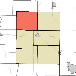 Location in Union County | |
| Coordinates: 39°41′34″N 84°58′50″W / 39.69278°N 84.98056°WCoordinates: 39°41′34″N 84°58′50″W / 39.69278°N 84.98056°W | |
| Country | United States |
| State | Indiana |
| County | Union |
| Government | |
| • Type | Indiana township |
| Area | |
| • Total | 28.54 sq mi (73.9 km2) |
| • Land | 28.39 sq mi (73.5 km2) |
| • Water | 0.15 sq mi (0.4 km2) 0.53% |
| Elevation | 791 ft (241 m) |
| Population (2010) | |
| • Total | 845 |
| • Density | 29.8/sq mi (11.5/km2) |
| ZIP codes | 47325, 47353 |
| GNIS feature ID | 0453144 |
Brownsville Township is one of six townships in Union County, Indiana, United States. As of the 2010 census, its population was 845 and it contained 351 housing units.[1]
Geography
According to the 2010 census, the township has a total area of 28.54 square miles (73.9 km2), of which 28.39 square miles (73.5 km2) (or 99.47%) is land and 0.15 square miles (0.39 km2) (or 0.53%) is water.[1]
Adjacent townships
- Abington Township, Wayne County (north)
- Boston Township, Wayne County (northeast)
- Harrison Township (east)
- Center Township (southeast)
- Liberty Township (south)
- Jennings Township, Fayette County (southwest)
- Waterloo Township, Fayette County (west)
Cemeteries
The township contains these two cemeteries: Richland and Woods Chapel.
School districts
- Union County-College Corner Joint School District
Political districts
- Indiana's 6th congressional district
- State House District 55
- State Senate District 43
References
- United States Census Bureau 2007 TIGER/Line Shapefiles
- United States Board on Geographic Names (GNIS)
- IndianaMap
- ↑ 1.0 1.1 "Population, Housing Units, Area, and Density: 2010 - County -- County Subdivision and Place -- 2010 Census Summary File 1". United States Census. Retrieved 2013-05-10.
External links
| |||||||||||||||||||||