Brownsville Road
Brownsville Road is a road in Allegheny County, Pennsylvania. It has had several names over its history, and was also known at the Red Stone Road and the Brownsville Plank Road, or Southern Avenue.
Pre-history to the 19th century
The road follows the route of ancient trails and footpaths connecting Redstone Old Fort with the "forks of the Ohio", a distance of 26 miles (42 km).[1] It later became the road connecting Pittsburgh with Brownsville, Pennsylvania, and from there via Nemacolin's Path to Virginia and points further east. It was a major route for travel by stagecoach and Conestoga Wagon.[2] The road was significant during the Whiskey Rebellion, particularly its southern half.
19th century
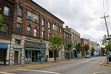
It was likely to be part of the route traveled by Meriwether Lewis from Harper's Ferry to Pittsburgh in 1803.[3] and was the route along which telegraph lines first entered Pittsburgh. There are relatively few roads connecting the floodplain of the Monongahela River with the higher elevations to the south and west of the river. Originally, Brownsville road connected with the floodplain by the road now known as Arlington Avenue. In 1851 a turnpike company was chartered by the State of Pennsylvania to pave the Pittsburgh end of the road, and to connect it with South Eighteenth Street.[4] Aften this construction, the northern end of Brownsville Road connected to S. Eighteenth Street, just south of the Pittsburgh, Virginia and Charleston Railway.[5] Many cemeteries were sited along the road as part of the Rural Cemetery Movement. In the 1880s, an "electric road" was built from Mount Oliver to the Concord Presbyterian Church, an area of Carrick also known as Crailo or Spiketown. Brownsville Road became a route out of the city for amusement and entertainment, including prize fighting.[6]
20th century
Streetcar tracks of the Pittsburgh Railways Co. ran down the road until 1971, ending just past the border of Pittsburgh at the "Brentwood Loop". They were part of the 53 Carrick, the 53's rush-hour variant 47 Carrick via Tunnel, and the 77/54 North Side–Carrick via Bloomfield ("Flying Fraction"), streetcar runs.
References
| Wikimedia Commons has media related to Brownsville Road (Pittsburgh). |
- ↑ Washington, George; Crawford, William (about 1780). A map of the land abt. Red Stone and Fort Pitt (map). Peter Force map collection 59. Library of Congress. OCLC 5400980. Check date values in:
|date=(help) - ↑ M'Murtie, Charles R. (1900). "The Brownsville Road: Redstone Road in Olden Times". The Pittsburgh Press (September 23). Retrieved 7-01-2008. Check date values in:
|accessdate=(help) - ↑ Gilbert, David T. "Route of Meriwether Lewis from Harper's Ferry, Va. to Pittsburgh, Pa,". Retrieved 7-01-2008. Check date values in:
|accessdate=(help) - ↑ "Records of Department of State: Birmingham and Brownsville Macadamized Turnpike Road, East Birmingham and Mt. Oliver Turnpike and Plank Road Company". Retrieved 7-02-2008. Check date values in:
|accessdate=(help) - ↑ Map http://images.library.pitt.edu/cgi-bin/i/image/image-idx?view=entry;cc=hopkins;entryid=x-20090330-hopkins-0026
- ↑ "Prize-Fight Near Pittsburg" (PDF). New York Times. 4 July 1883. Retrieved 18 January 2009.
Coordinates: 40°24′58″N 79°59′10″W / 40.416°N 79.986°W