Brownsmead, Oregon
| Brownsmead, Oregon | |
|---|---|
| Unincorporated community | |
|
Grange hall | |
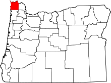
 Brownsmead Location within the state of Oregon | |
| Coordinates: 46°13′3″N 123°32′29″W / 46.21750°N 123.54139°WCoordinates: 46°13′3″N 123°32′29″W / 46.21750°N 123.54139°W | |
| Country | United States |
| State | Oregon |
| County | Clatsop |
| Time zone | Pacific (PST) (UTC-8) |
| • Summer (DST) | PDT (UTC-7) |
| ZIP code | 97103 |
| Area code(s) | 503 and 971 |


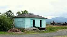
Grange hall
Rail station
Brownsmead is an unincorporated community, on a distributary of the Columbia River called Saspal Slough, in Clatsop County, Oregon. According to Oregon Geographic Names, it is named after W.G. Brown, a Portland engineer, and had been previously named Brody. There was a post office in Brownsmead from 1919 to 1975.
Historic photos of the Brownsmead fish station, located where Davis Creek feeds into Blind Slough, reveal docked gillnetting boats. One such boat is shown in the boat hoist, resting above the water by several feet on the dock.[1]
References
| |||||||||||||||||||||