Brown Township, Hendricks County, Indiana
| Brown Township | |
|---|---|
| Township | |
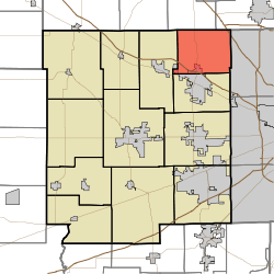 Location in Hendricks County | |
| Coordinates: 39°53′17″N 86°22′45″W / 39.88806°N 86.37917°WCoordinates: 39°53′17″N 86°22′45″W / 39.88806°N 86.37917°W | |
| Country | United States |
| State | Indiana |
| County | Hendricks |
| Government | |
| • Type | Indiana township |
| Area | |
| • Total | 25.35 sq mi (65.65 km2) |
| • Land | 25.32 sq mi (65.58 km2) |
| • Water | 0.03 sq mi (0.08 km2) 0.12% |
| Elevation | 909 ft (277 m) |
| Population (2010) | |
| • Total | 11,593 |
| • Density | 457.9/sq mi (176.8/km2) |
| GNIS feature ID | 0453138 |
Brown Township is one of twelve townships in Hendricks County, Indiana, United States. As of the 2010 census, its population was 11,593.[1]
History
Brown Township was named for James Brown, a pioneer settler.[2]
Geography
Brown Township covers an area of 25.35 square miles (65.7 km2); of this, 0.03 square miles (0.078 km2) or 0.12 percent is water. The stream of Pump Run flows through this township.
Cities and towns
- Brownsburg (north quarter)
Adjacent townships
- Eagle Township, Boone County (northeast)
- Pike Township, Marion County (east)
- Lincoln Township (south)
- Middle Township (west)
- Perry Township, Boone County (northwest)
Cemeteries
The township contains eight cemeteries: Ballard, Bethesda, Evans, Johnson, Macedonia, Marvel, Smith-Shepherd and Sparks.
Major highways
Airports and landing strips
- Fuller Field
References
- "Brown Township, Hendricks County, Indiana". Geographic Names Information System. United States Geological Survey. Retrieved 2009-09-24.
- United States Census Bureau cartographic boundary files
- ↑ United States Census Bureau American FactFinder
- ↑ History of Hendricks County, Indiana: Together with Sketches of Its Cities, Villages and Towns. Inter-State Publishing Company. 1885. p. 470.
External links
| |||||||||||||||||||||||||